Kathmandu, May 21
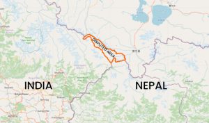
The government of India says the decision of the government of Nepal to issue a new political map incorporating the disputed Kalapani-Limpiyadhura region is a unilateral act, and it will not accept it.
Hours after Nepal’s Land Management Minister Padma Kumari Aryal officially unveiled the map in Kathmandu, the official spokesperson of the Indian Ministry of External Affairs, Anurag Srivastava, states, “This unilateral act is not based on historical facts and evidence.”
The statement reads further, “It is contrary to the bilateral understanding to resolve the outstanding boundary issues through diplomatic dialogue. Such artificial enlargement of territorial claims will not be accepted by India.”
India has also appealed to Nepal to refrain from “such unjustified cartographic assertion and respect India’s sovereignty and territorial integrity.”
“We hope that the Nepali leadership will create a positive atmosphere for diplomatic dialogue to resolve the outstanding boundary issues.”
Earlier this month, when Nepal protested India’s unilateral opening of a new link road using the disputed land, India had said the road completely lied in the Indian territory, assuring it would hold talks over the issue one the Covid-19 crisis was over. Nepal, in response, had said it was not ready to wait till the end of the Covid-19 crisis.
Before that, Nepal had protested India’s publication of the new political map in November 2019, urging to hold talks to settle the issue. India, however, had not responded to two requests to hold a foreign secretary-level meeting.