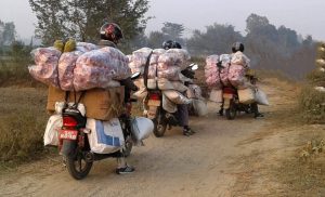
Nepal has held pride in its historical battles and the bravado of the forefathers who fought gallantly against any foreign invasion. In history, one of the most debated and remembered fights is in Kalapani. Nepal won the fight back then, but in the recent decade, the Kalapani dispute has resurfaced.
Nepal’s Kalapani dispute with India is one of the sore spots for any Nepali citizen as it is yet to be in the clear. People time and again are seen pouring even their extreme forms of expressions against the other country. Without the plurality of the content that might inundate you at the peak of the dispute, here is a summary of what the Kalapani dispute is all about.
Basics of the area of dispute
Before we get into the details, first let us know the details of the area of the Kalapani dispute.
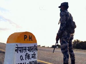
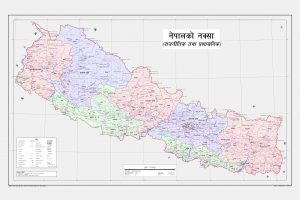
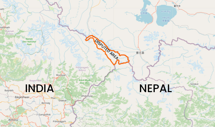
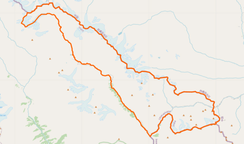
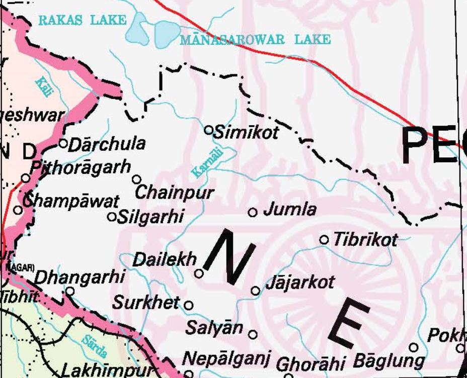
Kalapani is the area in the Darchula district of the Sudurpaschim province of Nepal that borders the eastern front of Uttarakhand in India. The area lies in the southern half of the Kalapani river basin or on the banks of the Mahakali river. It is situated at 3,650 m to 6,180 m above sea level and has an area of 35 square km. It only has some 100 people living in the area.
Kalapani is a tri-junction point between India, Nepal and China. It is important to Nepal and India regarding the border dispute. But, not just that, India and China also find the area important as the pass to build a road connecting Indian pilgrims to Kailash Mansarover in Tibet. It is also a place of strategic importance for India and China to logistically build up military troops on the border.
Reasons behind the Kalapani dispute
In the early 19th century, the East India Company (EIC) that was ruling India began expanding its territories and reached northwards near Nepal. Soon after, on November 1, 1814, a war broke out with the Nepali side.
In 1815, the British general Sir David Ochterlony managed to evict the Nepali soldiers from Garhwal and Kumaon. A year later, the war came to an end with the Sugauli Treaty.
In October–November 1962, the Sino-Indian war broke out. The same year, then Indian Prime Minister Jawaharlal Nehru wrote a personal letter to the then Nepali King Mahendra requesting the latter to let the retreating India Army stay temporarily in an open area in Kalapani.
India’s encroachment on Lipulekh, another area in the region, first came to light during the Panchayat period, but no effort was made for negotiations. There are no records in Nepal to suggest that these demarcations were done jointly between the British East India Company and Nepal.
King Mahendra is blamed for allowing Indian troops into Kalapani after the 1962 India-China war, at India’s request, even though there are no official records or statements substantiating the blame. According to foreign affairs expert Bhek Bahadur Thapa, King Mahendra never gave written permission but had planned to take up this issue with India when the war ended, but he never came to it.
India and China agreed even as far back as 1954 to allow Indian pilgrims to Kailash Mansarovar to use the Lipulekh pass.
The shifting of the international boundary based on changes in the course of a mountain river does not hold water, literally. Even if these changes in the course of the river were depicted in the maps published by the Survey of India during British rule, they cannot be used as a reference in deciding the international border.
But, in November 2019, India included the disputed area in its official map, the region east of Lipu Khola as a part of its territory. Later, Indian Defence Minister Rajnath Singh inaugurated the Indian road via the disputed tri-junction of Nepal, India and China. These events brought the Kalapani dispute to a new height, and Nepal also retaliated by amending its constitution to include the disputed region on its map also.
Contrasting claims
The Kalapani dispute is all about whether the Kalapani-Limpiadhura-Lipulekh land is a part of present-day India or Nepal. There have been several attempts to resolve this dispute.
- In the early 1970s, Nepali State Minister for Forest Bahadur Singh Etwal, from Darchula, had publicly raised the Kalapani dispute issue for the first time.
- On July 16, 1973, the Nagendra Prasad Rijal cabinet formed a panel with representatives from the Ministry of Home Affairs and the Ministry of Foreign Affairs to report on the encroachment from the ground. The report clearly mentioned that India had created an artificial Kali river to demarcate the border.
- In 1981, the Nepal-India Technical Level Joint Boundary Group was formed to demarcate the borders and maintain the dilapidated and disappeared boundary pillars.
- In 1981, Dwarika Nath Dhungel, then chief district officer of Darchula, prepared a ground report suggesting Nepal should demarcate the Nepal-India border and deploy security forces.
There was no substantial progress in solving the Kalapani dispute till 1990. After Nepal got democracy, the dispute gained traction again.
- In 1991, the Mahakali Protection Commission Kailali-Kanchanpur team submitted a memorandum to Prime Minister Girija Prasad Koirala, objecting to Indian encroachment of the disputed area and the Tanakpur water-sharing agreement.
- In 1992, lawmaker Prem Singh Dhami also spoke about the Indian encroachment in the upper house.
- In 1996 after the signing of the Mahakali Treaty, the Kalapani dispute issue entered the public domain.
- On May 19, 1998, the then CPN-ML organised a Kalapani march for 18 days to reach Kalapani. In the same year, its student union also organised a similar march.
- On June 29, 1998, nine Nepali political parties wrote to then UN Secretary-General Kofi Annan about the Kalapani dispute caused by the Indian encroachment. In response, the UN asked Nepal to submit a proposal in the name of the Nepali government.
- During the 1998 SAARC Summit, Prime Minister Girija Prasad Koirala reminded his Indian counterpart Atal Bihari Vajpayee of the unresolved Kalapani dispute.
- On July 17, 1998, Kalapani was again discussed in the fifth meeting of the Joint Working Group between the two countries.
- On August 10, 1998, CPN-UML leader KP Sharma Oli registered a motion in parliament demanding the withdrawal of Indian forces from Kalapani.
- In 1999, Indian foreign minister Jaswant Singh said his side was willing to resolve the Kalapani dispute with negotiations during his Nepal and China visits. It did not bear results.
- In 2015, India and China agreed to the use of Lipulekh as a bilateral trading point.
- In 2016, the Maoist-aligned All Nepal Independent Student Union (Revolutionary) submitted a complaint to the UN Secretary-General Ban Ki-Moon over the India-China trade agreement.
- In 2019, India issued its new map, and the Nepali Congress and CPN-UML jointly moved forward to amend Nepal’s constitution to include Kalapani in Nepal’s national map.
- In 2020, Nepal’s national charter was amended to make Kalapani, Lipulekh and Limpiyadhura a part of Nepal.
Thus began the downpour of official statements from the government of Nepal and India. Nepal’s Ministry of Foreign Affairs said India’s move was a ‘unilateral act’ and urged India to stop all the activities as it was against the bilateral understanding.
India replied claiming the disputed Kalapani area was its area and was a part of its plan for the 70km-road to travel to Lake Mansarovar in Tibet.
Nepal has been suggested to appeal to the International Court of Justice (ICJ) with the right documents and maps related to its demarcation after the Sugauli Treaty.
Yet, the Kalapani dispute is not solved yet with both sides making contrasting claims further.
India’s claim
- India’s claim about the Kalapani dispute is based on the British Survey of India maps between 1857-1881 and later.
- The Indian military has had 17 barracks and checkpoints since the 1962 Sino-Indian war in Kalapani. Even in 1969, when Prime Minister Kirti Nidhi Bista convinced Delhi to remove all its checkpoints on the Nepal-China border, India did not remove the one in Kalapani.
- Nepal’s first map published by the Topographic Survey of Nepal in 1976 did not include Kalapani, Lipulekh and Limpiyadhura.
- Chinese President Xi Jinping and Indian Prime Minister Narendra Modi reached an understanding to boost their trans-Himalayan trade by making the trek to Lake Mansarovar for the Indian pilgrims through the Lipulekh pass.
- India claims the source of the Kali river is a smaller tributary that flows down from Lipulekh and the approximately 372sq km of land belongs to it.
India says it is ready to give up the disputed land if Nepal gives enough solid evidence. In May 2020, Indian Army Chief Gen MM Naravane gave a statement saying that Nepal’s move to publish a new map and raise the Kalapani dispute was influenced by a third party, to which Nepal Army had also reacted.
Nepal’s claim
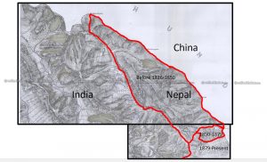
- The 1816 Sugauli Treaty cost Nepal one-third of its territory but demarcated Kalapani and the disputed area as Nepal. Article 5 of the treaty states Nepal is east of the Mahakali (Kali) river with its source at Limpiyadhura. This is the beginning of the Kalapani dispute.
- The maps published by the British Survey of India in 1816, 1827, 1850 and 1856 clearly mark Limpiyadhura, Lipulekh and Kalapani as Nepal.
- Nepali geographers Mangal Siddhi Manandhar and Hriday Lal Koirala say attempts were made in 1857 and 1881 to misname the Kali river. This has been claimed as a cartographic move without any knowledge given to the government of Nepal.
- When the international boundary is concerned around the rivers, it is the median line or the navigational channel (thalweg) that defines the boundary. In cases when the river changes course, the initial epoch of the river should be used as the boundary line, which is Limpiyadhura in this case.
- In 1962, King Mahendra responded to a personal letter by Indian Prime Minister Jawaharlal Nehru to let the retreating India Army stay temporarily in Kalapani (temporarily being the keyword here).
- Even after the war, not only did the Indian Army leave the post, it expanded its presence at Kalapani building new infrastructure.
- Nepal’s own official map in 1975 showed Lipu Khola as the boundary between Nepal and India, and not the Mahakali River.
- Nepali maps published in textbooks during the Panchayat period incorporate these regions.
- But, in November 2019, India included the disputed area in its official map, the region east of Lipu Khola as a part of its territory. Later, Indian Defence Minister Rajnath Singh inaugurated the Indian road via the disputed tri-junction of Nepal, India and China. These events brought the Kalapani dispute to a new height, and Nepal also retaliated by amending its constitution to include the disputed region on its map also.