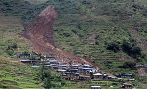
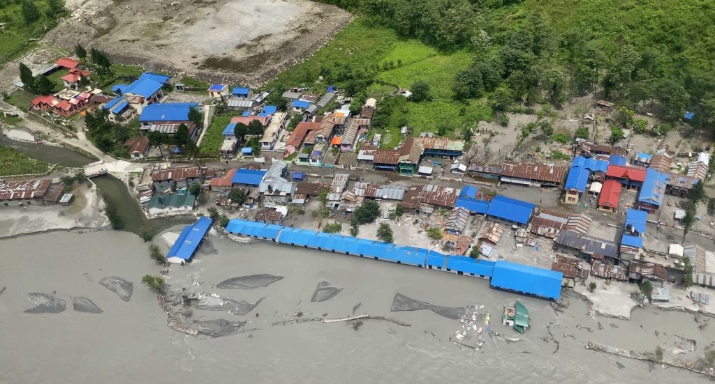
Dol Maya Gurung’s family settled in a house built on public land in Taal village after their house in Siran Tal of the Manang district in Nepal’s Gandaki province was washed away. Following the flood on June 15, 2021, the small village where 34 people from seven other families used to live turned into a floodplain full of sand.
Almost all human settlements in the district were affected by floods and landslides that year.
Dol Maya Gurung had a hotel and farmland in the Siran Tal village. Tourists could be welcomed with vegetables and fruits grown in their gardens and fields. But the public land of Tal village, where Dolmaya and other displaced families live today, does not have any agricultural land or place for tourist accommodation. The ward chairman of Naso rural municipality-1, Min Rashi Gurung, says the floods destroyed the Siran Tal village unlivable as everything including houses and farmland got destroyed.
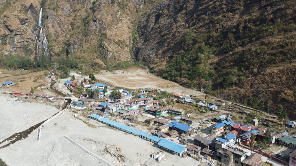
Manang had no human casualties due to the floods and landslides, but 59 houses were completely destroyed, and many others were not livable. The district headquarters, Chame, was cut off from the road network for months when nearly 54 kilometres of roads were destroyed by floods and landslides.
The peak of the monsoon after two months will mark the second anniversary of the Manang floods. But still, for a want of reliable rehabilitation, the locals fear being climate refugees in the long run.
Unprecedented rainfall
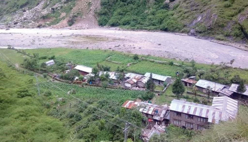
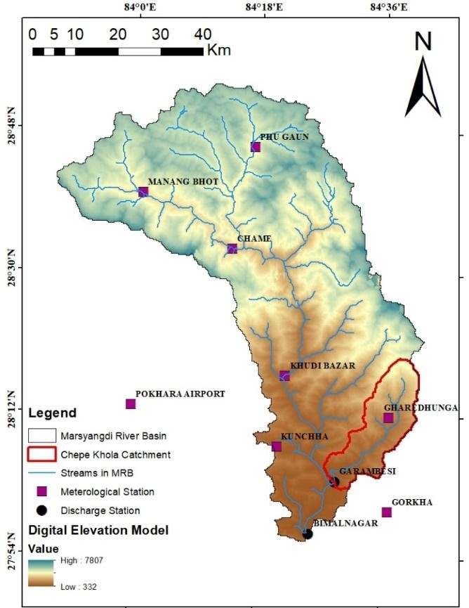
The Marsyangdi river and all the rivulets in Manang had high flow, with surges risking human settlements and destroying many cultivable lands. Settlements like Danakyu and Pisang faced a double risk: cutting by the big river and deposition by rivulets. The settlement and the only airport in the whole district in Humde were at risk. Farmlands were severely destroyed in Pisang, Bhratang and Bhraka.
Ang Dorje Lama, a 72-year-old resident of Ngawal, Manang Ngisang village, says he had never seen or experienced rain like the one in June 2021. Many elders echo him consistent with the data recorded by the rainfall measurement stations.
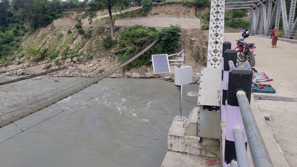
According to the Department of Hydrology and Meteorology (DHM), the rain gauge station at Humde in Manang recorded 82.2 mm of rain on June 1. This is the heaviest rainfall ever recorded since the station’s establishment in 1987. Based on the rainfall status of Humde from 2015 to 2020, the average rainfall in June is only 42 mm. Until June 16, 2021, 197 mm of precipitation was recorded at the station, which is 469 per cent of the average rainfall recorded there. In May of that year, 693 per cent of the average rainfall occurred.
Humde’s average annual rainfall is 375 mm, but only in two months of 2021, it received 363 mm of precipitation. Similarly, the average pre-monsoon (March-May) rainfall in Humde is 135 mm, while it received 232 mm of rainfall that year.
According to a study published in 2022, two rivers in the Gandaki basin, Marsyangdi and Budhigandaki, have experienced a significant increase in total water flow over the last 20 years, mainly due to the rise in rain-induced flow. In the rain-shadow region, which has never been affected by the monsoon, the main reason for floods and inundation in 2021 is the excessive rainfall in a short period.
Ngamindra Dahal, a climate researcher and the president of the Nepal Water Conservation Foundation for Academic Research, points out the need to place the currently established rain gauges at higher altitudes and to study hourly measurements rather than day-to-day measurements. According to Dahal, the rain gauge station in Humde does not represent rainfall at all places in Manang. Humde is at an altitude of 3,350 metres, Khangsar is at altitude of 3756 metres, Tal Bazar is at an altitude of 1,700 metres, Dharapani is at an altitude of 1,860 metres, and Chame is at an altitude of 2,060 metres.
According to Bibhuti Pokhrel, the information officer at the Department of Hydrology Meteorology, the department has also realised the need to establish more measuring stations, but the department is conscious of their long-term operation. On top of that, measuring station management and operation at high altitudes is still challenging, the department says.
During the 2021 Manang floods, the major Marsyangdi river and small rivulets overflowed, risking human settlements, agricultural land and micro-hydropower plants. Settlements in Manang, Humde, Danaque, Tachai and Pisang were under double threat from the main rivers Marsyangdi and small rivulets.
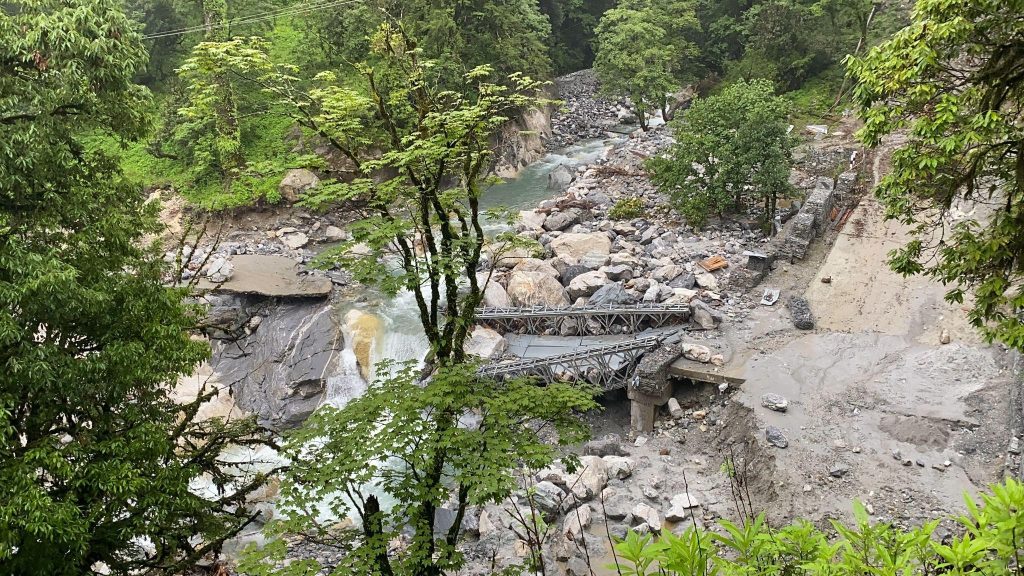
According to the District Administrative Office, rivulets named Ghattekhola and Chattukhola located in Chame rural municipality destroyed six houses in Chame and swept away the structures (culverts, dams, and hump pipes) of two micro-hydropower projects in Timangkhola and Syarkukhola.
The Marsyangdi river basin
Kapli Gurung, a former chairman of the District Development Committee, says the name of the Marsyangdi river originated from ‘Ma Syang Kyu’ in the Gurung language spoken in upper Manang, which means a river flowing with golden water.
Marsyangdi is an essential tributary of the Gandak basin, spread over a watershed area of about 4,100 square kilometres. This river basin is spread in Manang, Lamjung, Tanahun and Gorkha districts.
According to the flow recorded by the DHM station at Bimalnagar in Tanahun from 1987 to 2015, the average flow in the Marsyangdi river is 217 cubic metres per second. During the rainy season, three times more water flows in Marsyangdi than the average annual flow. Since 70 per cent of the total flow is contributed by rainfall, Marsyangi naturally floods during heavy rains. According to the department’s real-time streamflow (raw) data, the Marsyangdi river flowed at the height of 12.4 metres at Bimalnagar station at 7:30 pm on June 1, 2021. This was 174 per cent of the average height in June 2021.
Problematic rescue and rehabilitation
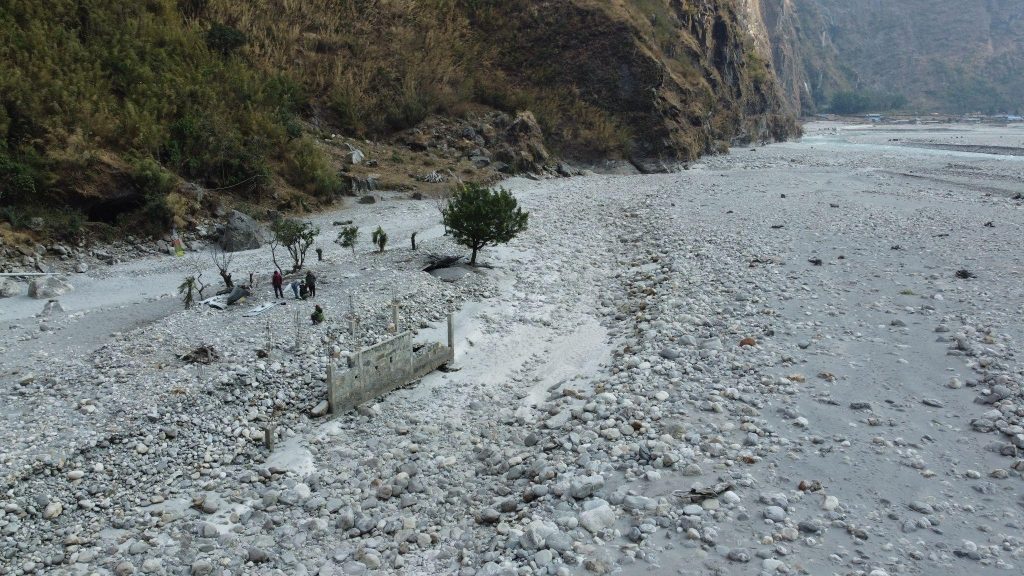
Haunted by the 2021 Manang floods, the locals of Tal village feel that the village is not safe as the houses and schools on the banks of the river were submerged during the disaster. The Tal village already has been a place of concern even before the likely floods. According to Manang Land Commission chairperson Lakshmi Lama, Siran Tal and Tal villages are worst hit by the disaster, but the commission has yet to make a clear idea about what to do in the case of the villages displaced by the disaster.
Water flow controlling efforts (river training) is ongoing in Tal with several organisations’ contributions. But no one knows if such river control work can stop future events like the 2021 floods.
Heavy rains are not the only cause of the Manang floods. When glaciers break, landslides stop the Maryangdi river for a while and open the water all at once. Even when hydropower dams burst, the risk of flood is also the same. The technicians of the offices accept that these structures currently being built are not made with attention to that.
But not only in the case of the Manang floods but there are also problems all over Nepal in determining the priority of post-disaster reconstruction and rehabilitation works. Polden Chopang Gurung, a former member of the House of Representatives, says he repeatedly took time in the parliament to draw the government’s attention to the 2021 Manang floods. As a result, the government has done some work by declaring it a disaster-hit district, but he says the work still needs to be improved.
Gurung says Manang needs a long-term strategy to avoid the effects of climate change. The representatives of the local governments in Manang confirm the need for more resources to solve the problems created by the Manang floods. Chhiring Gurung, the vice chairperson of Manang-Ngisang rural municipality, stresses providing sufficient provincial and central government budget for river training works to save Himalayan villages across the riverbanks.
He adds that the local government alone cannot respond to disasters caused by the global problem of climate change.
According to Chin Bahadur Ghale, the chairperson of the District Coordination Committee, Manang has become like a hotspot for disasters caused by climate change. Ghale adds that due to drier conditions than before, the risk of forest fires and avalanches has increased. While there is a risk of heavy rainfall like in the case 2021 Manang floods, the shortening of the time of snowfall might lead to more disasters.
Chairperson Ghale believes that the District Disaster Management Committee should be made effective and empowered to work in disaster management strategy, pre-preparation and post-disaster management instead of making it a body that works only in rescue after a disaster.
Hope from the loss and damage fund
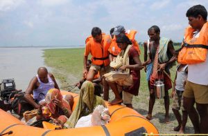
Not only in Manang, the Melamchi and Indrawati rivers of the Sindhupalchok district in central Nepal also experienced extreme rainfall and flooding around the same time as the Manang floods. Dambar Bahadur Aryal, the mayor of Melamchi municipality at the time, says that due to the flooding, properties worth more than Rs 30 billion were lost, and 215 families had to be displaced. Helambu rural municipality reported that the flood has affected half a dozen settlements and washed away nearly 150 houses.
A study report published in 2016 by climate experts Divesh Khadka and Dinesh Pathak about the maximum temperatures in the Marsyangdi basin from 1956 to 2010, showed an increasing trend, and the trend was higher and more significant than a rising trend of minimum temperatures. According to climate expert Dr Sudeep Thakuri, also the dean of the Faculty of Science and Technology of Midwest University, “If Manang, which is located in the high Himalayas with a cold climate, has experienced increased temperatures compared to the average temperatures in the past, it is a climate change impact.
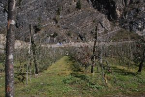
Due to climate change impacts, snow-capped mountains are turning black. Farmers of Manang say that when it rains in the lower areas of Manang and there is heavy snowfall in the upper regions, production will flourish. But when happens in unexpected seasons, the result will be the opposite. In 2021, it snowed in the third week of October, around a month earlier than the expected time, destroying crops.
It is clear from the experience of local people and the scientific publications by experts that such incidents have been more frequent and intense due to climate change. On the other hand, it can be seen that the assistance provided nationally is insufficient for these displaced families. In such a situation, climate finance, such as the Loss and Damage Fund as promised by the 27th climate change COP, should relieve the population living in remote Himalayan settlements like Manang’s Siran Tal village. But there is no immediate scope for such relief.
But climate change researcher Ngamindra Dahal says the results of the new fund decision will not make any immediate impact at the local level. Nonetheless, Dahal says it is necessary to be ready to lobby as soon as the mechanisms are set by referencing scientific studies that confirm that these disasters are caused by climate change rather than just a few news reports.
Stating that the number and intensity of disasters caused by climate change such as the 2021 Manang floods have been increasing in the past decade, Anil Pokharel, the chief executive officer of the National Disaster Risk Reduction and Management Authority, says there is a need to create a regional integration mechanism and minimize and manage the risks brought by climate change in the Hindu Kush Himalayas. The authority is constantly collaborating on making the HKH region, especially Nepal, a climate-resilient region.
Reporting for this story was supported by Internews’ Earth Journalism Network.