
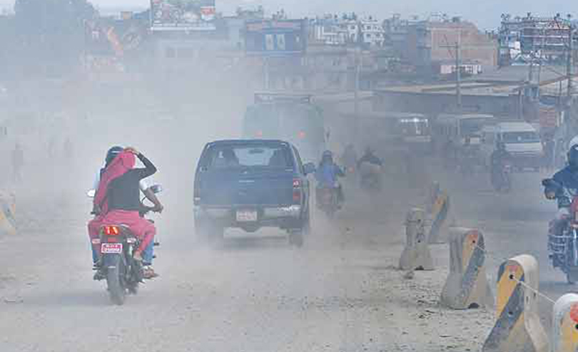
Nepal’s lung cancer crisis cannot be understood by looking only at hospital records or individual risk factors; we must also ask a fundamental geographical question: where are people being exposed to the conditions that increase their risk? The air we breathe is not the same everywhere. Rapid urbanisation, traffic emissions, household air pollution, industrial activities, dust, biomass and solid-fuel use, and changing environmental conditions create highly uneven patterns of exposure across Nepal. Yet these spatial inequalities often remain invisible in conventional health statistics.
In recent years, cancer has stood as a major global public health challenge. Notably, the incidence of lung cancer is rapidly increasing in developing countries. According to the World Health Organisation, cancer is a leading cause of death worldwide, accounting for nearly 10 million deaths in 2024, or nearly one in six deaths. The most common cancer is lung cancer, with 2.6 million cases. It is the most common cancer seen in men, primarily due to factors such as smoking, low air quality, haphazard industrialisation, and lifestyle changes. It is not distributed evenly across all geographical locations; the risks vary by place due to environmental conditions and social behaviours. It is also associated with access to healthcare services. In Nepal, there has also been a significant increase in the incidence of lung cancer in the last decade, highlighting the seriousness of this problem and the need for municipal-level analysis for a better understanding of its impacts.
In a country like Nepal, which has geographical diversity, the distribution of diseases is attributed to spatial characteristics. However, spatial studies are limited in our country. Many global and regional-level spatial studies indicated that the risk of lung cancer varies geographically. Various factors such as environmental and geographic exposures, population density, smoking rate, lifestyle, geographical structure, and dietary habits determine its risk, which has not been studied in our country. According to the International Agency for Research on Cancer (IARC), there were 1,477 new cases of lung cancer reported in Nepal at a rate of 7.1 per million.
According to a study by Silpkars 2022, Nepal’s age-standardised incidence rate (ASIR) is 80.9, and the mortality rate (ASMR) is 54.8 per million, which is exceptionally high. The high mortality rate of lung cancer, especially among men in urban areas, poses a serious public health challenge. This rate is notably higher in the age group of 70 to 74, a high-risk demographic. In the Kathmandu Valley, the ASIR of lung cancer in men is 18.1 and 10.4 in women, indicating the severity of the disease in the capital. However, in rural areas like Rukum, this rate is only 13.2 and 5.2, respectively, demonstrating significant variation in lung cancer risk according to location.
Spatial health research is essential for studying complex and location-specific health issues. Geographic Information System (GIS), satellite data, and spatial statistical techniques are used to identify patterns of disease spread, risk areas, and associated geographic and environmental factors. Such spatial technology and methods play a significant role not only in disease control but also in policy-making. Unfortunately, spatial health research has not yet been given sufficient priority in Nepal.
This research on the relationship between lung cancer and PM2.5 in the Bagmati Province is one of the first studies expected to guide future research, health interventions, and policy-making by spatially mapping risk areas at the municipal level. Such research can serve as a practical tool for the scientific community, policymakers, public health advocates, and local governments.
In this context, ‘Spatial Health Research’ is essential to understand the local distribution of diseases and to identify risk areas. Public health research focuses on individual or demographic details, but geospatial analysis makes it possible to clearly illustrate the interaction between disease, environment, and geographic features. The study of disease spread, risk areas, and potential causes such as pollution intensity, population density, and geographic barriers can be conducted using GIS and remote sensing technologies. Such analysis can contribute significantly to developing targeted and effective disease control policies.
For this reason, my recent research was conducted to identify the potential relationship between PM2.5 and lung cancer in the Bagmati Province. The study evaluated the spatial and temporal distribution of lung cancer cases from 2012 to 2021. It included a spatial mapping of high-risk areas and analysed the extent of PM2.5 impact at the municipal level. Factors such as demographic conditions, urbanisation, land use, and lifestyle were also included. In the context of Nepal, this type of localised health study has been conducted for the first time, representing an innovative effort in Nepal’s health research field. The findings of this research are expected to contribute to pollution control, formulating public health strategies, and reducing chronic diseases like lung cancer. Specifically, by providing clear information on the level of risk in local bodies of Bagmati Province, it will be possible to carry out evidence-based interventions targeting them.
Why lung cancer is 6 times higher in some municipalities
Bhaktapur Municipality faces a lung cancer rate of 24.39 per 100,000 people, which is six times the provincial average. Meanwhile, just 50 kilometres away in rural Raksirang, the rate sits at 3.85. The first-ever municipal-level disease mapping in Bagmati Province reveals how air pollution is silently creating cancer clusters across Nepal’s most populated region.
Nepal ranked 7th globally for air pollution in 2024, with toxic particle levels 8.5 times above World Health Organization safety limits. But this decade-long study of 2,183 lung cancer cases shows the danger isn’t spread evenly. The air you breathe depends entirely on your area, and so does your cancer risk. Between 2012 and 2021, lung cancer cases in Bagmati Province surged 128 per cent, jumping from 119 to 271 annual diagnoses. That’s roughly seven new patients every day. Among them, 60 per cent are men, reflecting global patterns linking male smoking rates to lung disease. But one statistic defies simple explanation: urban areas like Kathmandu Metropolitan City show lower rates than smaller municipalities despite worse air quality.
The answer lies in population density. High case numbers in the capital get diluted across millions of residents, lowering the calculated rate. Meanwhile, places like Panchkhal Municipality (14.64 per 100,000) and Sunapati Rural Municipality (12.96) show concentrated risk despite smaller populations. Raw numbers hide local crises.
Using satellite pollution data and decade-long hospital records, the study mapped cancer “hotspots” where cases cluster far beyond statistical chance. Bhaktapur, Sindhupalchok, and Kavre districts light up red year after year. These aren’t random; they’re areas where PM2.5 pollution (microscopic particles from vehicles, factories, and burning) reaches dangerous concentrations.
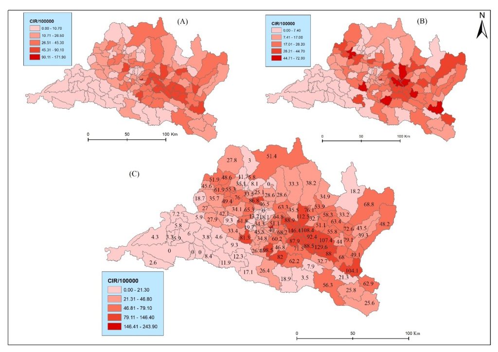
Figure 1. Municipal-level lung cancer risk presented on a map: (A) CIR for males, (B) CIR for females, and (C) total CIR.
The relationship between pollution and cancer appears to be growing stronger. In 2018, PM2.5 levels explained 59 per cent of cancer variation across municipalities, which is the highest correlation found in the decade. Earlier years showed weaker links, suggesting pollution’s effects compound over time. Residents breathing toxic air in 2012 may only develop cancer a decade later, making today’s pollution tomorrow’s epidemic.
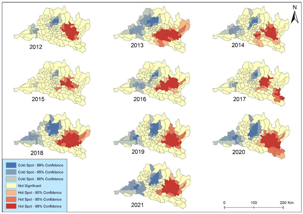
Figure 2. Shows the municipal-level hotspot from 2012 to 2021 in Bagmati Province.
This data gap reveals a deeper problem: Nepal lacks coordinated cancer registries. Without comprehensive tracking, health officials can’t know the full scope of the crisis or target interventions effectively. Urban residents near major hospitals get counted; rural patients often don’t. Tiny particulate matter (PM2.5) penetrates deep into lungs and enters the bloodstream. Long-term exposure triggers inflammation, damages DNA, and provides pathways for cancer development. The 2018 hotspot analysis marked a turning point: cancer clusters aligned almost perfectly with pollution zones around the Kathmandu Valley.
This relationship shifted over the decade studied. Some years showed weaker correlations, reflecting pollution’s variable impact or the time lag between exposure and diagnosis. Cancer doesn’t appear overnight. A resident exposed to severe pollution in 2015 might not receive a diagnosis until 2021, complicating efforts to draw direct cause-and-effect lines.
This marks Nepal’s first municipal-level spatial health study, creating a roadmap for targeted intervention. Health officials can now see exactly which municipalities need immediate pollution controls, early cancer screening programs, and public awareness campaigns. The data removes guesswork from resource allocation.
The study’s broader message challenges one-size-fits-all policies. Average pollution levels across Bagmati Province mask extreme local variation. A provincial strategy that treats all municipalities equally wastes resources in low-risk areas while leaving high-risk residents underserved. Bhaktapur needs different interventions than Rukum, where cancer rates run half as high. Behind these statistics are families. Husbands diagnosed in their 60s, wives facing treatment costs that bankrupt households, children losing parents. The age group from 70 to 74 shows the highest risk, but working-age adults increasingly appear in cancer wards.
The hotspot maps also reveal environmental injustice. Wealthier residents can afford homes in cleaner areas, access better healthcare, and detect cancer earlier. Poorer communities concentrate in industrial zones with the worst air quality and fewest health services. Geography becomes destiny. The government now has evidence-based answers to critical questions: Where should mobile screening units go first? Which municipalities need emergency pollution reduction? Where will the next cancer cluster emerge?
Early detection programs targeting high-risk municipalities could catch cancer when it’s still treatable. Pollution controls in hotspot areas such as traffic restrictions, industrial emission standards, and construction dust management might prevent future cases. Both interventions require political will and funding. This study demonstrates that the burden of lung cancer in Bagmati Province is unevenly distributed, with municipalities experiencing substantially higher risks that closely align with long-term exposure to fine particulate matter (PM2.5). These findings reinforce the importance of integrating spatial evidence into public health planning and environmental governance.
Geospatial health offers a powerful way to make these risks visible by bringing together lung cancer data, air-quality measurements, satellite observations, land-use patterns, population density, road networks, socioeconomic conditions, and healthcare accessibility. By mapping where environmental exposures overlap with vulnerable populations and where lung cancer cases are concentrated, we can move beyond simply counting patients toward understanding the places and environmental conditions that may shape disease risk.
This matters particularly in Nepal, where limited resources demand targeted prevention rather than a one-size-fits-all response. Geospatial evidence can help identify high-risk communities, guide environmental monitoring, prioritise screening and prevention, and support policymakers in directing resources where they are most needed. If lung cancer is partly a story of place, exposure, and inequality, then Nepal needs to put geography at the heart of its cancer prevention strategy. The question is no longer only how many people are developing lung cancer. It is also where, why there, and what can we do before exposure becomes disease? Lung cancer is no longer solely an individual health issue; it has become a geographic and environmental challenge that demands location-specific solutions.
Nepal can no longer rely on province-wide or national averages when designing cancer prevention strategies. Instead, policymakers should prioritise municipal-level interventions in identified hotspot areas. Strengthening air quality monitoring, enforcing stricter emission standards for industries and vehicles, improving urban planning, controlling construction dust, and promoting cleaner household energy sources are essential steps to reduce population exposure. At the same time, the health system should establish a comprehensive, nationwide population-based cancer registry integrated with GIS and environmental data to enable continuous surveillance of cancer patterns and emerging risks. Strengthening collaboration among the Ministry of Health and Population, the Ministry of Forests and Environment, local governments, and research institutions will be critical for translating scientific evidence into effective public policy.