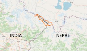
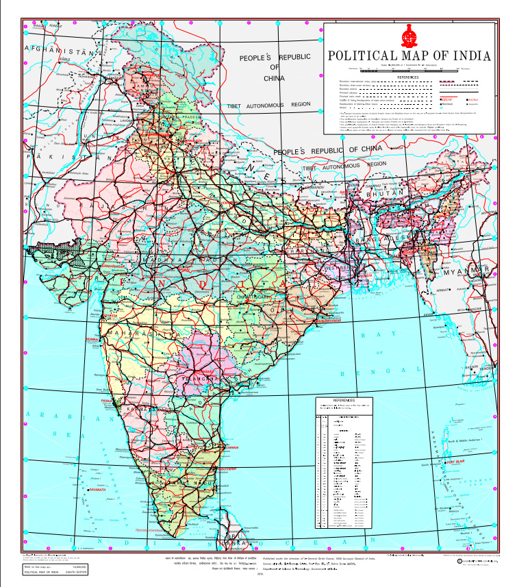
The new political map of India issued by New Delhi last Saturday to demarcate the new union territory of Ladakh, has also made headlines in neighbouring Nepal. Following the publication of the map, the Nepali media reported that India has laid claim over Kalapani, which Kathmandu considers Nepali territory.
This Saturday, Prime Minister KP Sharma Oli hosted an all-party meeting to discuss the issue, during which all the parties supported the government’s stand that the map should not be accepted and diplomatic initiatives should be taken to resolve the issue.
But what is the dispute all about? We explain.
What’s the borderline?
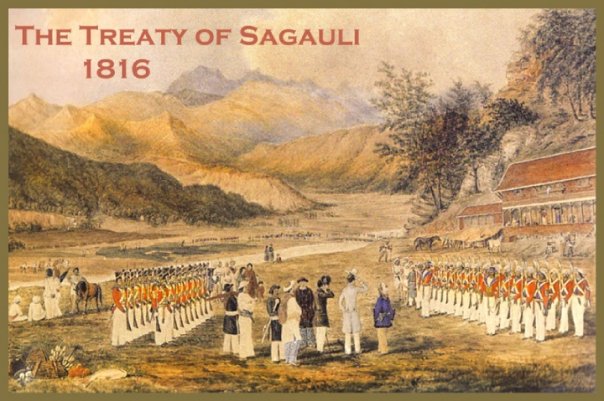
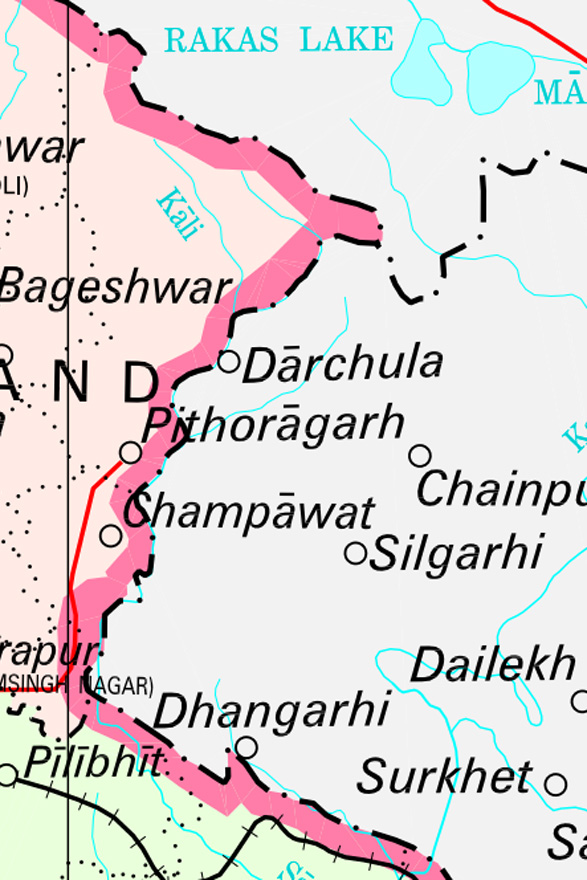
On March 4, 1816, Nepal signed a treaty at Sugauli of India with the then-British rulers of India; and it is considered the defining document about the border between the two countries. The Sugauli Treaty clearly designates the Kali river (also known as Sharada in India and Mahakali in downstream Nepal) as Nepal’s western frontier.
So what’s the dispute?
Everyone agrees that the Kali serves as the border between the two countries. However, there are at least three viewpoints about the location of the Kali and its origin.
The first perspective
Nepali experts say the Kali originates in Limpiya Dhura, which is around 30 km west of Kalapani. Researcher Ratan Bhandari states in a recent Kantipur TV report that India had issued a political map on April 24, 1856, based on the Sugauli Treaty and that map shows Limpiya Dhura as the river’s origin. According to him, there are three villages: Kuti, Nabi, and Gunji–settled by Nepalis on the east of the river, but India claims these villages belong to India. He says the Land Revenue Office in the Baitadi district of Nepal still has records that the villagers used to pay land tax to the Nepal government until the 1940s.
Likewise, Bhandari says the discipline of hydrology traditionally considers the longest tributary of a river the main source of the river whenever more than two streams form a river, arguing the river from Limpiya Dhura is the Kali referred to in the Treaty of Sughauli. Meanwhile, veteran journalist Bhairav Risal, who worked as a Nepal government employee for some time, has said that he visited Limpiya Dhura as an enumerator during the 1961 population census, stressing this place is the origin of Kali.
An Indian traveller on Manasarovar Yatra in 2011 also mentions the local Indian officials saying that Kalapani was taken by India on ‘lease’ from Nepal and the Kali river referred to by Bhandari is the actual border between the two countries.
The second perspective

In a 2015 article, retired British military officer and trekker Sam Cowan explains that India recognises another river as the Kali.
He writes, “…the river flowing from Lipu Lekh, which previously did not have a name, was designated by the British as the Kali and the river that formerly had that name became the Kuti Yangti, as it flows down near Kuti village. This change meant that Nepal lost some thousands of hectares of territory north of the river running down from Limpiya Dhura.”
Hence, Ashok Kumar Gupta writes for the Institute of Peace and Conflict Studies that India has been ruling the region for just a few years after the Sugauli Treaty.
“Official sources in India claim that the administrative and revenue records dating back to 1830s (available with the UP state government) show that Kalapani area has traditionally been administered as part of Pithoragarh district.”
Bhandari says around 385 square km area, almost two-thirds of the area of Kathmandu Valley, has been encroached on by India by shifting the border.
Cowan explains that the British military officers ruling in India intentionally changed the border and legitimised it owing to the place’s strategic importance in connection with China. Because Lipu Lekh is also a border between India and China, shifting the border will make the trade route between these countries shorter and the trade activities can operate directly via this point.
In the latest step of legitimisation, India and China signed a bilateral agreement about operating a checkpoint in Lipu Lekh in 2015, recognising it as a bilateral crossing point, not a tri-junction. The government of Nepal expressed its concerns after that agreement also, but nothing happened towards correction.
Whenever Nepal raises the issue, India states that the border dispute between the countries should be settled without affecting the 2015 India-China agreement, but Nepali officials do not accept it.
The third perspective
Yet, there are some other people who believe that the bordering river originates neither in Lipiya Dhura nor in Lipu Lekh, but in Kalapani. Cowan says a small stream originates from Kalapani, which later meets the river originating in Lipu Lekh. Nepali authorities claim that the stream originates in an artificial pond that India created to further complicate the dispute so that it could prolong its rule in Kalapani. Though there are not any official records stating this stream to be the borderline, Indian pilgrims going to Manasarovar through this route perceive as the borderline, he suggests.
What has Nepal been doing?
Most analysts agree that the dispute has turned perennial due to Nepal’s silence. Bhandari says all the Nepali maps issued after 1975 are wrong as they were prepared on the basis of Indian maps, without doing field surveys.
Meanwhile, the Director General at Nepal’s Department of Survey, Prakash Joshi, informs that India has been using the same map since 1962. Different sources inform that King Mahendra, who ruled from 1955 to 72, was aware of the changes that India made to the map and the establishment of Indian army camps in Kalapani. However, he could not protest as he feared it would put the partyless Panchayat system that he introduced in 1950 at risk.
Most Nepali survey officials refuse to comment further on the issue as a joint commission led by foreign secretaries of the two countries is mandated to resolve the conflict. The commission is currently dormant.
However, it is interesting that the new Indian map contradicts India’s claim to Kalapani. The new map surprisingly recognises the river flowing from Limpiya Dhura as ‘the Kali river’, which the Sugauli Treaty identifies as the border between Nepal and India. However, the river is included in the territory of India. This shows that India has changed its historical stance on the origin of the Kali and conceded that the river Kali indeed originates from Limpiya Dhura, as claimed by Nepal.
What does India say?
In response to a question about the recent dispute, the Indian Ministry of External Affairs spokesperson Reveesh Kumar last week said, “The new map has in no manner revised our boundary with Nepal.”
He also added, “The boundary delineation exercise with Nepal is ongoing under the existing mechanism… We reiterate our commitment to find(ing) a solution through dialogue in the spirit of our close bilateral friendly relationship.”
What next?
Reports say that India, upon Nepal’s request, has agreed to hold foreign secretary-level talks with Nepal over the various border disputes, including the one over Kalapani.