Prime Minister Pushpa Kamal Dahal’s four-day official visit to India from May 31 to June 3 has been touted as a successful trip by the state media in terms of the goodwill shown by India’s PM Narendra Modi towards the resolution of outstanding border disputes between Nepal and India through bilateral diplomatic mechanisms.
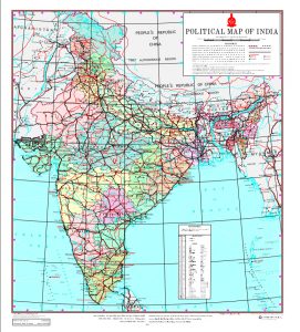
The Limpiyadhura-Lipulekh-Kalapani sector dispute, which is a major territorial dispute that encompasses an area of around 400 square kilometres, can be viewed as a ‘frozen’ dispute that has been an irritant in the relations between India and Nepal, especially since the Indian occupation of Kalapani after the 1962 Sino-Indian War. This is a very strategic area for India from a military point of view, but for Nepal, this is a loss of territory that defines its sovereignty and independence.
Dahal is positive that the issue can be solved as during his recent visit, Modi proposed to swap lands between the two countries like India did with Bangladesh. But it is not going to be easy as the land Nepal will likely want to swap, is currently occupied by the Indian military.
In Nepal, there is speculation that the land swaps on the Indian side are related to the territories within the 52 km Siliguri Corridor, which can serve as a connection between Nepal and Bangladesh and is often known as the Chicken’s Neck.
If history is anything to go by, land swap is going to be a disputed issue in both Nepal and India as prime ministers from both countries will be challenged by political leaders and citizens.
Details are not yet clear. If land swaps are to be carried out fairly, India will need to exchange lands that are located within the Chicken’s Neck area, which consists of a 20km by 20km strip of land. This is a daunting task as the sovereignty and independence of Darjeeling in West Bengal, will also be affected.
Since West Bengal is ruled by Mamata Banerjee’s All India Trinamool Congress, which was actively involved in challenging land swap negotiations with Bangladesh, the Indian state government will hold significant influence over any land swap agreements.
In certain cases, particularly regarding water-sharing treaties with Bangladesh, the state government has not always followed the directives of the central government, resulting in delays in treaty signings.
India has also signed a Memorandum of Understanding (MOU) with Nepal, aiming to import 10,000 MW of electricity over the course of the next decade.
It is understood that Nepal will initially export 50 MW of electricity to Bangladesh, and in the future, there is a possibility of additional exports beyond the 10,000 MW that Nepal plans to sell to India over the next decade.
But that is an afterthought, as Nepalis are questioning whether the land swaps will be conducted with fairness and equality. They believe that the crucial details need careful consideration, and Nepal should engage its experts to thoroughly prepare and negotiate the land swaps. The government is accountable to the people and should be open to renegotiation if necessary.
The following is an overview of the Bangladesh-India Model for resolving disputes concerning land, river, and maritime boundaries between Nepal and India.
The two countries can resolve disputes through bilateral negotiations, third-party intervention, or by seeking recourse in the International Court of Justice (ICJ).
India and Bangladesh have utilised both bilateral talks and the ICJ to address their boundary issues. The case studies presented below highlight a multifaceted approach that was effectively employed in settling boundary disputes between India and Bangladesh, which Nepal can learn from.
A glimpse of Bangladesh-India border issues and their resolutions
Historical perspective
The 4,156-km-long international border between India and Bangladesh is of the longest land border in the world. Both India and Bangladesh (erstwhile East Pakistan) inherited their borders from colonial times during the British Raj in South Asia.
Their international border follows the Radcliffe Line, which was defined by the British architect and chairman of the Border Commission Sir Cyril Radcliffe during the partition of India in 1947.
Land boundary agreement
A new nation Bangladesh, which was born in December 1971 after the Liberation War, signed the Land Boundary Agreement (LBA) with India in 1974. Although the Indian Prime Minister Indira Gandhi and the founding father of Bangladesh Prime Minister Sheikh Mujibur Rahman signed the LBA, it was ratified only in 2011 by India.
A revised version of the agreement was adopted by the two countries on May 7, 2015, when the Parliament of India passed the 119th Amendment to the Indian Constitution and the revised LBA was signed on June 6, 2015, in Bangladesh.
Five Indian states share their international border with Bangladesh: 262 km in Assam, 856 km in Tripura, 180 km in Mizoram, 443 km in Meghalaya and 2,217 km in West Bengal. The Bangladesh divisions of Mymensingh, Khulna, Rajshahi, Rangpur, Sylhet and Chittagong are situated along the border.
Under the LBA, the two countries also agreed to exchange enclaves and adverse possessions, which were the outstanding border issues, which were agreed to be resolved in the 1958 Nehru-Noon Accords.
There were 111 Indian enclaves (17,160.63 acres) within Bangladesh and 51 Bangladeshi enclaves (7,110.02 acres) within India. The residents in the enclaves were given a choice either to reside in the enclaves or to move to the country of their preference after the exchanges.
As far as adverse possessions were concerned, India received 2,777.038 acres of land and transferred 2267.682 acres to Bangladesh. As a result of the land swap, Bangladesh gained more territory than India.
There are different tales surrounding the origin of the enclaves. Some suggest that they were formed during intense card games or chess matches long ago between two local kings, the Raja of Cooch Behar and the Maharaja of Rangpur. While others say it is a result of a botched expansion of the Mughal empire.
There are also some who say a drunk British officer sprinkled ink on a map and some call this territorial accident, a result of a careless division of Bengal by Radcliffe who delimited the boundaries based on rough sketches.
Whatever the reasons, the problems regarding the enclaves were successfully sorted out and sealed during the visit of Indian Prime Minister Narendra Modi to Bangladesh in 2015 and the return visit of the Bangladeshi Prime Minister Sheikh Hasina (daughter of Sheikh Mujibur Rahman) to India in 2017.
Read also: These 11 maps show how India encroached upon Nepali land

Tin Bigha Corridor
In 1982, as part of the LBA between India and Bangladesh, a lease was granted indefinitely to Bangladesh for the Tin Bigha Corridor—a land bridge measuring 170 meters in length. This corridor connects Dahagram-Angarpota, the largest Bangladeshi enclave situated within India’s Cooch Behar district. As part of the agreement, Bangladesh ceded Berubari.
After years of nationalistic and communal politics in both India and Bangladesh, as well as the removal of General Mohammed Ershad from power in Bangladesh, the Tin Bigha Corridor was partially opened on June 26, 1992. Subsequently, on October 19, 2011, the corridor was made accessible 24 hours a day.
Read also – Explainer: What is the Kalapani controversy between Nepal and India all about?
Transboundary rivers and water disputes
Bangladesh has around 400 rivers. It shares 54 transboundary rivers with India, the most famous ones being the Ganges, Brahmaputra and Teesta (GBT). India is the upper riparian country, whereas Bangladesh is the lower riparian country. Bangladesh has riverine water disputes with India regarding the diversion of water from the Ganges, Teesta and other transboundary rivers.
Bangladesh encounters significant obstacles in mitigating floods during the monsoon season and coping with droughts in the dry season. In August 1988, during the rainy season, devastating floods ravaged Bangladesh, submerging nearly two-thirds of the country.
In August 2019, India and Bangladesh held a water secretary-level meeting of the Joint River Commission (JRC) in Dhaka. During the meeting, the two countries agreed to collect data and prepare water-sharing agreements for seven rivers—Manu, Muhure, Khowai, Gumti, Dharla, Duhkumar and Feni.
India is confronted with a significant strategic challenge in its northeastern region due to the growing influence of China in Bangladesh. Given recent reports of China’s intention to construct dams on the Brahmaputra river in Tibet, there is a potential for India and Bangladesh to collaborate on water-sharing agreements concerning the river.
Here is the explanation of how the transboundary rivers and water disputes were resolved between Bangladesh and India:
Ganga river: The Ganges river enters Bangladesh through the Nawabganj district, where it spans the international border with India for approximately 110km. It continues to flow within Bangladesh for about 130km until it meets the Jamuna River. The width of the river ranges from 1.5km to 14km. Notably, the river experiences an average annual erosion rate of 10 square kilometres per year.
In 1975, India constructed the Farrak Barrage over the Ganges River in West Bengal. Its purpose was to prevent siltation in Hooghly port and divert water towards Kolkata. However, this led to water scarcity in northwestern Bangladesh during the dry season. The barrage is situated 90 km away from the Bangladeshi border. In December 1996, both countries signed a 30-year treaty to share Ganges water, which was based on a formula determining the flow at Farraka during the lean season annually.
Teesta river: This is a transboundary river that has its source in the Himalayas. It flows through the Indian states of Sikkim and West Bengal and joins the Jamuna river in Bangladesh. India constructed a barrage over the Teesta at Gazoldoba and started withdrawing water from it. India’s water withdrawal from the Teesta has led to a reduction in water flow during the dry season (November to May).
According to Bangladesh, the decreased water availability caused by these factors has led to reduced rice production in the Teesta and Brahmaputra river basins. In 1983, India and Bangladesh reached an ad-hoc agreement for sharing water, with India receiving 39 per cent, Bangladesh receiving 36 per cent, and the remaining 25 per cent left unallocated.
The water-sharing agreement for the Teesta river saw a positive shift in 2015 following a change in the Indian government and the agreement of Mamata Banerjee, leader of the Trinamool Congress, to support the central government of India in establishing a fair water-sharing agreement.
Feni river: This river, located in southeastern Bangladesh, is a transboundary river that originates in southern Tripura. It flows through Sabroom town before entering Ramgarh in Bangladesh, continuing its course through the country until it reaches the Bay of Bengal.
India is currently constructing a 150-meter-long, 4-lane bridge over the Feni river, which serves as a boundary river. The primary objective behind this project is to enhance economic integration between India’s North Eastern Region and its mainland.
The bridge will connect Tripura with the Chittagong port in Bangladesh, located just 70 kilometres from the India-Bangladesh border. This connectivity holds significant importance within the proposed economic corridor that spans India, Bangladesh, China, and Myanmar. Additionally, the development is expected to transform Sabroom into a prominent economic and transit hub. The river is navigable by small boats as far as Ramgarh in India, about 80 km upstream.
Bangladesh has been dealing with an unresolved border issue with India concerning a riverine boundary since the river changed its course between 2004 and 2006.
As a result, previously fertile land that belonged to Bangladesh now lies within Indian territory. India supports following the new course of the river, while Bangladesh maintains its position based on the old course. There have been discussions regarding the possibility of constructing an embankment to redirect the river to its original course.
In 2019, both governments signed an MOU to address the issue by allowing the withdrawal of 1.82 cusec water from the Feni river. This water is intended for drinking purposes for the people of Sabroom in Tripura.
Muhari river: Muhari is a riverine border between India and Bangladesh. This river has its source in the Lushai hills and enters Bangladesh through the Feni district before discharging into the Bay of Bengal.
The primary dispute between India and Bangladesh regarding Muhari revolves around the method of demarcation. Bangladesh proposed resolving the issue based on the Chakla Roshnabad Map of 1893, while India insisted on using the 1854 and 1892 maps. This difference in preferred maps has contributed to the ongoing disagreement between the two countries.
Due to a natural shift in the river’s course, a char (islet) or surfaced area was formed, which now occupies a significant portion of land on the Indian side. However, Bangladesh asserts its claim over this territory.
In an effort to address their border disputes, the two countries are engaged in debates regarding the application of the Helsinki Rules on the Uses of the Waters of International Rivers (1967), which could potentially assist in finding a resolution to their disagreements.
Maritime boundary resolutions at the Bay of Bengal
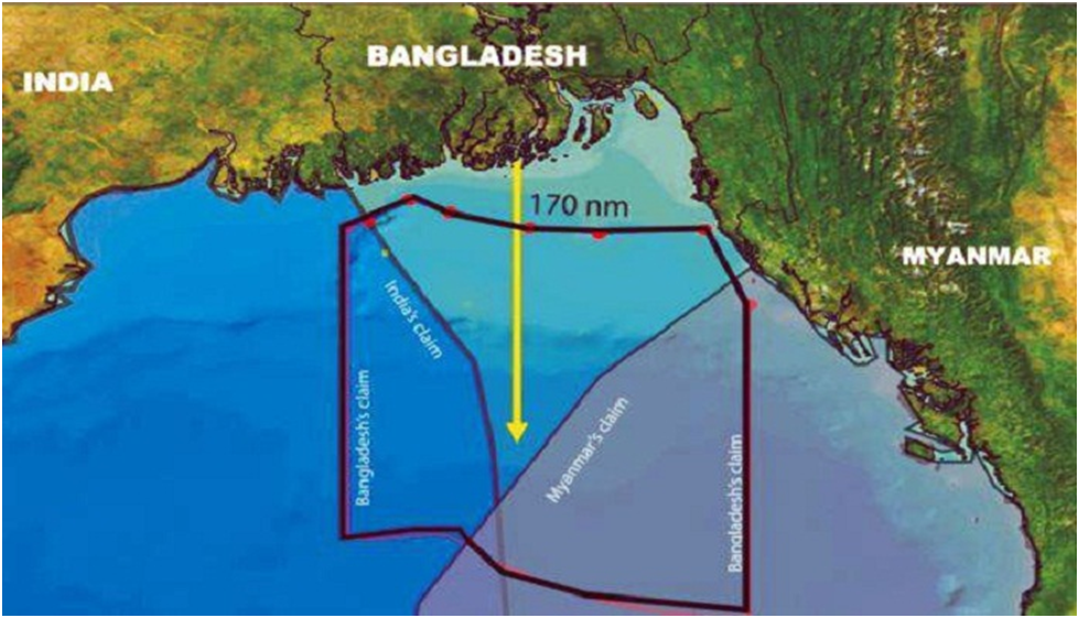
The long-standing sea boundary dispute between Bangladesh and India in the Bay of Bengal was resolved after more than three decades. On July 7, 2014, the Hague-based Permanent Court of Arbitration (PCA) issued its ruling, favoring Bangladesh.
As per the ruling, Bangladesh was awarded 19,467 km2 of the disputed areas out of the total 25,602 km2 in the Bay of Bengal. This decision, binding on both countries, was reached after extensive arguments, counter-arguments, site visits by judges, and examination of submitted documents over a period of approximately five years.
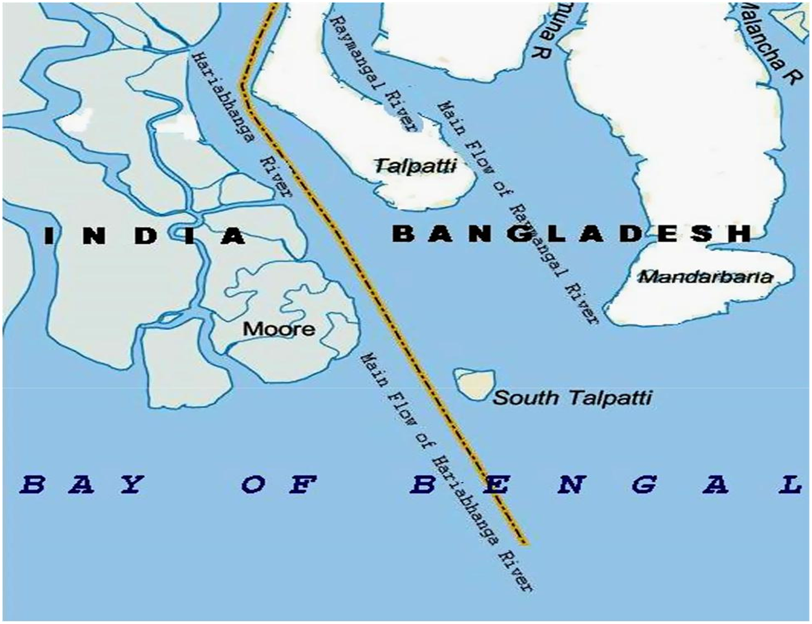
India and Myanmar advocated for delimiting Bangladesh’s maritime boundary based on the equidistance principle, while Bangladesh sought equitable solutions. Another issue between Bangladesh and India was the ownership claim over the newly formed island, known as South Talpatti to Bangladesh and New Moor Island to India. This 5 km2 island emerged after a cyclone in 1970 near the mouth of the border river Hariabhanga. The resolution of the dispute involved considering the main flow of the river to determine the ownership of the island.
Photos: Prabhakar Sharma
Sharma is an international boundary expert and geodetic engineer.