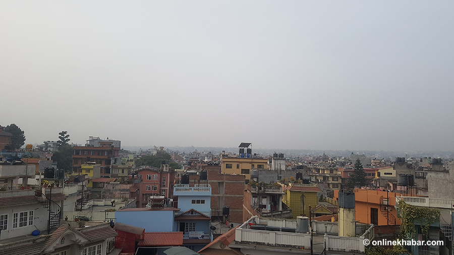
As the summer reached its peak this year a few weeks ago, you perhaps felt that Kathmandu has become hotter than before. You might have spent many hours restlessly, praying for the monsoon to arrive soon so that you could get some relief from the heat.
But, did you know that your feelings are backed by research? A recent study by two Nepali and an American scientists has found that the city’s temperature is steadily rising–this has been the case for at least the past two decades.
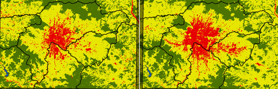
The study validates the common notion that the rate of increment in land surface temperature is inversely proportional to the amount of forest and agricultural land cover. It means converting forests into farmlands and farmlands into cities results in higher temperatures. More alarmingly, the research has found that the surface temperature is increasing in semi-urban and non-urban areas around Kathmandu, and the rate is even faster than that in the core city.
The study
Nepal’s Bijesh Mishra and Buddhi Raj Gyawali joined hands with the United States’ Jeremy Sandifer to conduct the study titled ‘Urban heat island in Kathmandu, Nepal: Evaluating relationship between NVDI and LST from 2000 to 2018′.
“We already knew that developed areas (those with more physical infrastructures) cannot store heat, rather emit it so they feel hotter than other areas. Such places are called urban heat islands,” Mishra informs, “But we also wanted to check if there was a significant change in the land surface temperature of the Kathmandu Valley over the past two decades.”
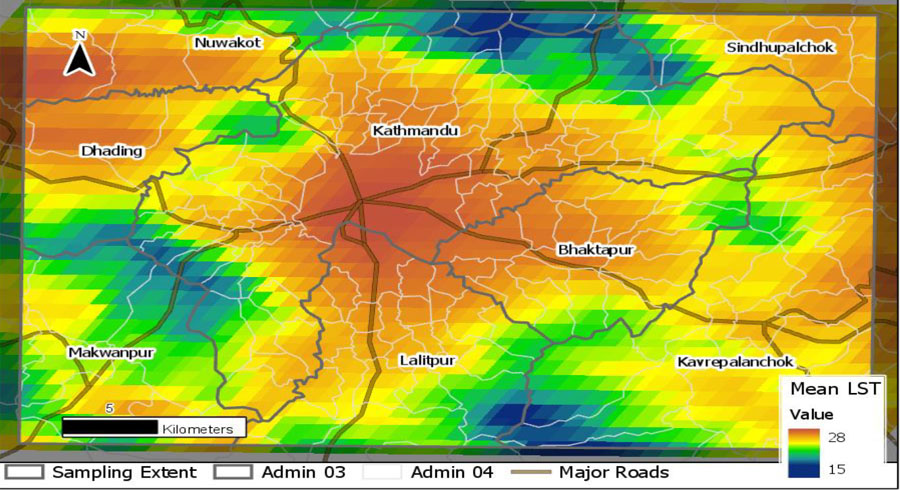
Mishra says the researchers studied changes in land surface temperature spatially, comparing Kathmandu Valley with the surrounding districts; and temporally, comparing the data from 2000 to 2018.
On the spatial dimension, “We found that the difference between temperatures in a forest land and in a developed land was 5 degree Celsius on average,” Mishra says, “It is quite alarming given that experts in other parts of the world express serious concerns with a figure of just around 2 degrees.”
On the temporal side, their report shows that the valley recorded an annual increase of 0 to 2 degree Celsius in the 18 years, an equally alarming figure.
Satellite images collected in March and October every year were used for the research as the researchers claim cloud-free images are more readily available in these two months.
Link with land cover distribution
As found in the research, “the highest temperature in Kathmandu Valley was in the developed land among the three major types of land covers, i.e. forest, agriculture, and developed land. It is clear that LST variation is largely driven by the type of land cover present.”
Mishra explains that average maximum temperature in Kathmandu was 28 degree Celsius and the average minimum temperature was just 15 degree. It was found that the average temperature was low in forest areas, medium in agricultural land and high in developed areas. The report informs that the mean land surface temperatures of forest lands, agricultural lands, and developed areas were 20.5, 23.2, and 25.3 degree Celsius, respectively.
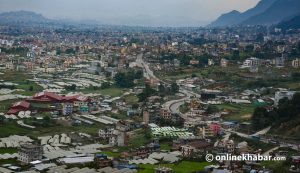
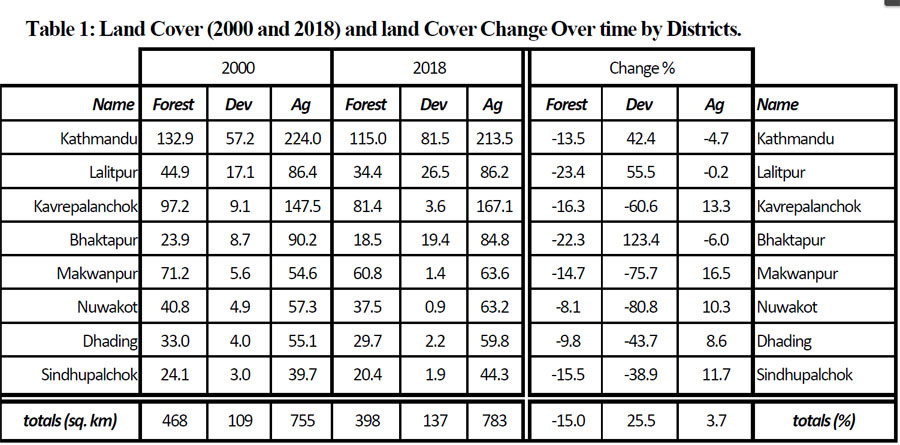
To learn about the distribution of land covers in and around Kathmandu, the research team selected eight districts–Kathmandu, Lalitpur, Bhaktapur, Kavrepalanchok, Makawanpur, Nuwakot, Dhading and Sindhupalchok–and studied the data of land distribution there.
“We found that the amount of forest and agricultural land was decreasing in the valley whereas the amount of developed land was significantly increasing,” Mishra says.
The research found that the amount of forest land decreased in all the districts. But, the cover of agricultural land increased in the five districts outside the valley. It roughly suggests that the forest land of yesteryears has turned into agricultural land in these districts. “In the same manner, the agricultural land will also turn into the developed land in future,” Mishra says, “Hence, the urban heat island effect continues to expand.”
The researcher claims that Kathmandu Valley is likely to face the brunt of the urban heat island effect more severely than anywhere in the country because the country’s urbanisation is centred here. “The trend is projected to continue till 2050; but the impacts are expected sooner than that.”
How sooner? By when? Mishra answers, “You cannot mark a point, but much sooner than you expect.”
The saturation point and beyond
While the gradual rise in temperatures in any place is quite obvious thanks to discussions about climate change and global warming across the world, this research has also found something that none or very few of the stakeholders have taken care of.
“The pace at which the land surface temperature is increasing is higher in the districts around Kathmandu than Kathmandu itself,” Mishra says, “Perhaps Kathmandu has already reached its saturation point. It cannot become hotter at the speed higher than this.”
Mishra seems right as metropolitan areas of the capital have a nominal amount of farmland and forest covers left to turn into developed areas. For the want of residential land, people aspiring to move to Kathmandu are gradually concentrating on suburbs of the valley. Gradually it is becoming insufficient, pushing people further outward, in districts like Kavre and Makawanpur, the study suggests.
The researchers state in their conclusion, “This suggests that the greenery inside the valley decreased significantly over the past two decades and the removal of vegetation is expanding towards the outer, newly developed semi-urban areas. These newly developing semi-urban areas are likely to become new urban centers that may have many of the same characteristics as the valley’s core.”
The study, however, has failed to suggest concrete recommendations to mitigate the negative impacts. “It was our limitation that we could not provide concrete solutions. We just reported what we observed,” Mishra defends. Rather, the researchers have suggested that additional studies are required to understand and explain the trend of urban heat island formation from multiple perspectives.