

We have often heard, and repeatedly experienced, that Nepal is highly susceptible to natural hazards. The reasons are largely clear. Geologically, the Himalaya is a relatively young mountain system, and its mountain-building process remains active. The continuing convergence of the Indian and Eurasian tectonic plates produces uplift, seismic activity and ongoing changes in the terrain.
Steep slopes, fractured and weak rock, intense monsoon rainfall concentrated within a few months, and glacier-fed high-mountain catchments further expose Nepal to earthquakes, floods, landslides, avalanches, rockfalls and debris flows carrying rock, soil, ice and water at high velocity.
Within this sensitive geography, roads, hydropower projects, markets, settlements, tourism infrastructure and other investments have expanded rapidly in recent decades. Climate change is adding further uncertainty by altering rainfall, glaciers, snow and hydrological processes across a natural system that is already highly dynamic. Its effects can extend from the high mountains through the middle hills to downstream riverine areas.
Nepal contributes only about 0.1 percent of global greenhouse gas emissions, yet the cost of climate-related risk is borne not only through lives lost during disasters but also through its long-term development. A World Bank study estimates that, without adequate action to address climate impacts, Nepal’s economy could be at least 7 percent smaller by 2050. In a country where major gaps in infrastructure and basic services remain, repeated destruction of roads, bridges, irrigation systems, homes and productive assets diverts scarce public resources from meeting new needs towards rebuilding what has already been lost. From the perspective of climate justice, it is difficult to regard as equitable a situation in which countries that contributed very little to global warming bear a disproportionate share of its consequences.
Yet the climate justice argument should not obscure the need to examine our own development decisions. Climate change can alter the probability, frequency or intensity of hazards, but whether a natural event becomes a major disaster also depends on where people live, where and how infrastructure is built, how development along rivers and steep slopes is regulated, and how seriously scientific knowledge influences planning and investment decisions. Disaster risk, in this sense, cannot be separated from the nature, pace, cost and sustainability of development.
The Rasuwa flood of August 26 brought this relationship into sharp focus along the Bhotekoshi–Trishuli river corridor. Preliminary scientific assessments indicate that a large mass of rock and glacial ice collapsed in the high mountains, generating a powerful flow that entrained rock, soil, water and other debris before entering the river system. As it travelled downstream, it encountered roads, bridges, hydropower projects, settlements, trade infrastructure and other economic activities that had expanded along the corridor over decades.
The resulting losses were extraordinary. Understanding the Rasuwa flood therefore requires more than explaining how the physical event began and travelled downstream. It also requires examining where and how settlements, infrastructure and investment have expanded within risk-prone terrain.
What actually happened in Rasuwa?
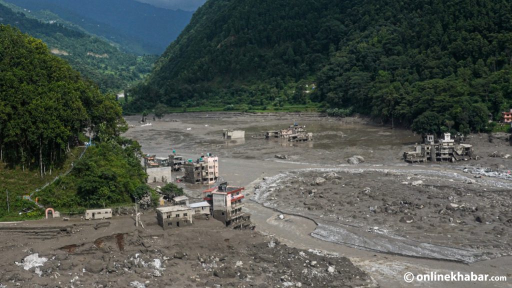
The Rasuwa flood began in high Himalayan terrain and propagated far downstream through the river system as an extraordinary hazard cascade. Preliminary evidence indicates that a large, steep slope involving rock and glacial ice failed suddenly. As the material descended, it entrained more rock, soil, water and debris and transformed into a powerful debris flow and flood. Its effects travelled through Lende Khola into the Bhote Koshi–Trishuli system, reaching settlements and infrastructure far downstream. Initial scientific assessments estimated flow velocities of around 40 to 50 metres per second.
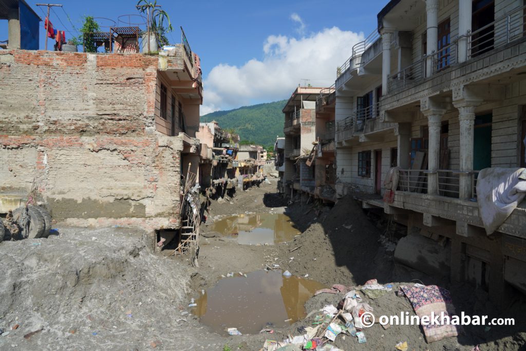
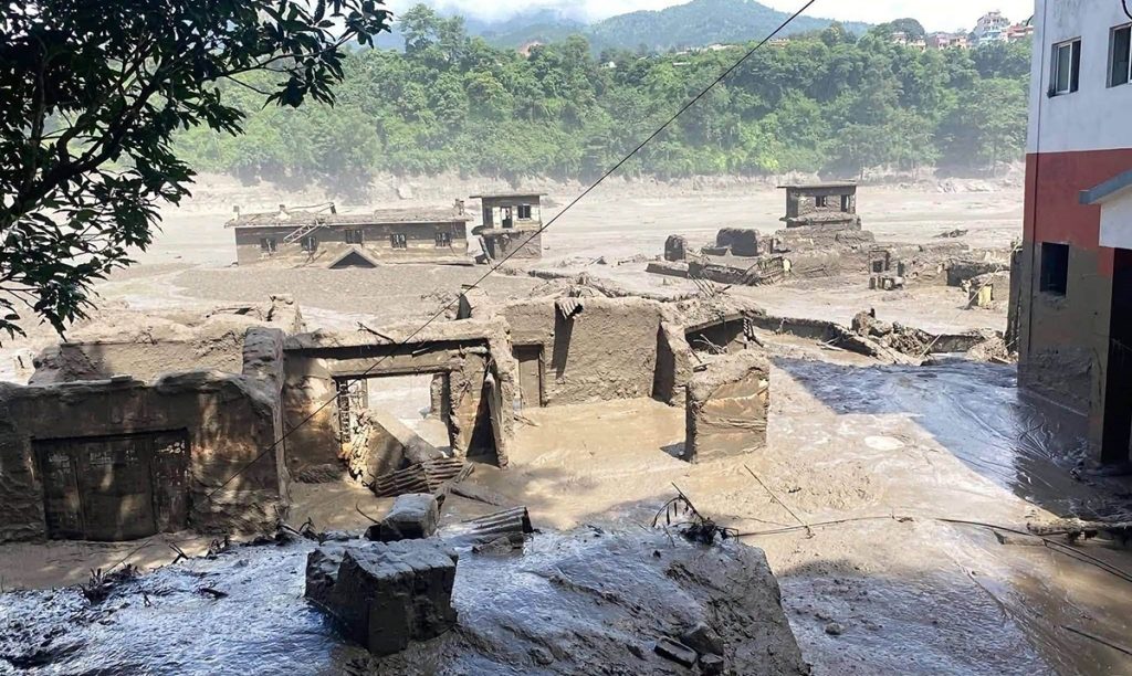
The human, physical and economic losses were extensive. According to the government’s preliminary damage and needs assessment available by 6 September, about 55 kilometres of roads, 37 motorable bridges, 68 suspension bridges, around 7,570 houses and 13 hydropower projects were affected. By September 8, 1,357 bodies had been recovered, while 5,326 people remained missing or unaccounted for. A total of 13,583 people had been rescued and 6,827 injured people had received medical treatment. Search, rescue, identification and verification were still continuing, so these figures remained provisional.
Early public discussion described the Rasuwa flood as a Glacial Lake Outburst Flood (GLOF). The scientific evidence available so far, however, indicates a more complex process. The United States Geological Survey (USGS) has provisionally interpreted the event as a destructive debris flow and flood following the rapid failure of a steep slope involving a glacier within Langtang National Park. The collapse generated seismic energy equivalent to an earthquake of about magnitude 5.2, although it was not a tectonic earthquake. USGS estimates that the resulting flow travelled nearly 100 kilometres downstream. It remains uncertain whether the initial failure was primarily a rock collapse incorporating part of a glacier or whether a large section of glacial ice itself became unstable.
This uncertainty matters. As Stuart Dunning, Professor of Applied Geomorphology at Newcastle University, has explained, a collapse of rock and ice at high elevation can change character as it moves downslope. Fast-moving material can entrain sediment and water, temporarily block a river and later generate a much larger downstream flow. Such an event cannot be understood adequately as a landslide, avalanche or flood in isolation. One process can trigger or intensify another, creating a hazard cascade.
ICIMOD’s preliminary assessment points to the same complexity. Its scientists suggest that a large volume of ice and rock may have entered Lende Khola, followed by exceptional downstream water-level rises. At Galchhi, the river rose by about nine metres within roughly 30 minutes, while at Malekhu the increase was about seven metres. Whether debris temporarily blocked the river and later released a larger surge remains under investigation. ICIMOD has also cautioned that, although climate change is altering glaciers, snow and high-mountain slopes, its precise role in this particular event cannot yet be determined.
The initial sequence therefore remains unresolved. Scientific reconstruction may eventually provide a clearer account of how the physical event developed. But it cannot, by itself, explain why it became such a large disaster. That requires examining the risk conditions of the affected corridor, how settlements and infrastructure were developed, and how far available knowledge of risk influenced planning and investment decisions.
Hazard and disaster are not the same
A basic distinction is essential to understanding disaster risk. A hazard is a natural event or process capable of causing harm to people, property or the environment. But a hazardous event is not, by itself, a disaster. Exposure refers to the presence of people, settlements, infrastructure, assets or economic activities within an area that may be affected. Their vulnerability depends on their sensitivity and on the capacity and resources available to manage risk. The interaction among hazard, exposure, vulnerability and capacity creates the potential for loss, or disaster risk. When that risk is realised through serious human, physical, economic or environmental losses, it becomes a disaster.
Viewed through this framework, the Rasuwa flood involves two very different timescales. The first is measured in minutes and hours, during which a physical event in the high mountains transformed into a powerful downstream flow. The second extends over decades, during which roads were built, bridges added, hydropower projects developed, border-trade infrastructure established, settlements expanded and economic activity increasingly concentrated along the river corridor.
Put simply, the destructive flood developed within minutes, but the people, settlements, roads, bridges, hydropower projects and other structures in its path had accumulated there through decades of development decisions. The scale of loss emerged where a rapidly developing natural process met a development pattern built over a much longer period. The risk exposed on August 26 was therefore not created that day. It had been accumulating through land-use, infrastructure and investment decisions.
The same river system experienced another major flood in July 2025. ICIMOD notes that Lende Khola experienced two major floods within fourteen months. This does not mean that both events had the same cause. Rather, it shows that the same corridor may be affected by different hazards and combinations of processes. It therefore needs to be understood as a dynamic, multi-hazard river corridor.
Whether the Rasuwa flood was technically a GLOF remains important for science, but it is not the only question that matters for planning. Equally important is how settlements, infrastructure and investment have expanded within a corridor exposed to different and potentially interacting hazards.
Not just a river, but an interconnected geo-system
Systems thinking remains weak in many urban and rural development plans and infrastructure decisions in Nepal. When a landscape is examined through isolated components, the relationships between them and the effects of change in one on another can be missed. Studying an unstable slope, analysing flow within a river reach, or designing a bridge are all necessary. But when an event travels through hillslopes, tributaries, the main river, roads, bridges, hydropower projects, settlements and administrative boundaries, overall risk cannot be understood by examining each element separately.
A river corridor is therefore more than a channel carrying water. It is a complex geo-system in which natural processes and human activities interact continuously. Topography and river processes are linked with roads, hydropower, settlements, livelihoods, land values, technology and public institutions. A new road does more than improve access. It can alter land values, attract markets and settlements, create demand for services and encourage further investment. Its effects extend beyond the project’s physical boundary.
The same interdependence appears in risk management. Embankments or river-control works may reduce flood or erosion risk up to a certain level, but they do not eliminate it. The risk remaining after protective measures is residual risk. If protection creates the perception that an area has become completely safe, additional settlement and investment may follow. Assessment therefore needs to consider how land use and investment patterns change after protection is provided.
Multiple development decisions also combine over time. A road, hydropower project or settlement expansion may appear technically acceptable when assessed independently. Yet as such decisions accumulate within the same corridor, accumulated exposure can increase and alter the overall risk. Planning must therefore consider the cumulative effects of infrastructure, land-use change and settlement expansion, not only the acceptability of individual projects.
Understanding these processes requires engineering geology, hydrology, cryospheric science, climate science and hydraulic engineering. Planning responsibility begins where this knowledge is translated into decisions. Planning must help determine where settlements and infrastructure can expand, where development should be regulated, where risk-reduction measures are necessary, and where further development should stop because residual risk exceeds an acceptable level.
The Rasuwa flood also exposes the limitations of a sectoral approach. Roads, hydropower, settlement development and river management may fall under different institutions, but their effects converge within the same geo-system. An integrated spatial land-use plan is therefore needed to connect these decisions and guide where infrastructure, settlements and investment may proceed, and under what conditions.
The problem is not a lack of risk-sensitive development policy
Nepal already has important policy and legal provisions for incorporating disaster risk into planning and construction. Frameworks exist for disaster risk reduction, safer settlement and building construction, climate adaptation, land use and local development control. The central issue is not whether policy exists, but how effectively it influences actual decisions on land use, settlement growth, infrastructure and investment.
The Disaster Risk Reduction and Management Act, 2017, the National Disaster Risk Reduction Policy, 2018, and the National Strategic Action Plan for Disaster Risk Reduction 2018–2030 provide a framework that goes beyond rescue, relief and reconstruction. They recognise the need to reduce existing risk, prevent new risk and integrate disaster risk reduction into development processes.
Following the Gorkha earthquake, Nepal introduced the Basic Construction Standards for Settlement Development, Urban Planning and Building Construction, 2015. These standards connected safer construction not only with individual buildings but also with settlement development, urban planning and development control.
The Local Government Operation Act, 20174 gives local governments authority to establish land-use standards based on geo-risk sensitivity, regulate building approval, oversee subdivision or plotting, and act on buildings considered unsafe from earthquakes or other hazards. Local governments therefore already possess legal instruments for linking risk information to development control.
The Land Use Act, 2019 and Land Use Regulations, 2022 provide a further basis for land classification, use and management. Their relevance extends to deciding what uses are appropriate in risk-prone terrain and where settlement and infrastructure expansion should be controlled.
Climate and urban policies reinforce the same direction. The National Adaptation Plan 2021–2050 calls for climate risk-sensitive land-use planning and mapping of risk-prone areas. The National Urban Development Strategy 2017 called for risk-sensitive mapping and a multi-hazard approach, while the National Urban Policy 2024 provides an updated urban policy framework.
Risk-sensitive settlement and spatial planning are therefore not new concepts in Nepal’s policy landscape. The principal weakness lies in integrated implementation. Policies, laws and standards are spread across institutions and levels of government, while their effects ultimately materialise in the same places. Their effectiveness should be judged by whether they actually produce safer settlements and infrastructure. The Rasuwa flood has made this implementation gap difficult to ignore.
When does risk enter the planning process?
The gap between policy and practice becomes clearer when we examine how plans are prepared. Many local governments prepare Integrated Urban Development Plans (IUDPs), physical development plans, transport plans, land-use plans and multi-hazard maps. These are necessary instruments. The critical issue is when risk information begins to influence actual planning decisions.
Consider an IUDP. It may contain maps of flood, landslide or earthquake hazards. But if future growth areas, major roads, economic centres, infrastructure priorities and the direction of expansion have already been decided before those maps are introduced, risk has not shaped the basic structure of the plan. The hazard map then becomes another thematic layer placed over an already determined development pattern.
Risk-informed planning reverses that sequence. Decisions on where settlements should expand, where roads should run, where major infrastructure should be located and which areas should accommodate future growth should not precede multi-hazard and risk analysis. Risk information should shape the location, form and direction of development from the outset.
This also broadens the meaning of preparedness. Early warning, evacuation routes, rescue equipment and emergency operation centres are essential, but they primarily help people and infrastructure already located within areas of risk. Land-use and development planning provide an earlier opportunity to limit new exposure before it is created.
Preparedness therefore begins when land uses are designated, road alignments chosen, infrastructure located, settlement-expansion boundaries set and future growth directions determined. Risk should not enter at the end of planning as a final check. It should be part of the decision framework from the beginning.
The question of where to develop

Once risk is incorporated from the outset, the next task is to determine where development is appropriate and what kind of development should be permitted.
Multi-hazard and risk analysis should provide the first screening. Areas where risk makes certain forms or intensities of development unacceptable should be identified first. Land within a high-risk debris-flow, flood or landslide zone cannot become suitable simply because it is close to a road, well connected to a market or inexpensive to service.
After such areas are screened out, the remaining land can be assessed through multi-criteria land suitability analysis. This should consider slope, geological conditions, river behaviour, agricultural productivity, environmental sensitivity, water availability, access to roads and services, existing settlements, infrastructure feasibility and local livelihood opportunities. These criteria are not fully interchangeable. Good accessibility, low infrastructure cost or high market value cannot compensate for an unacceptable level of risk.
The analysis can then identify different planning-suitability categories. Some areas may be appropriate for priority development. Others may allow limited development only under specified conditions and risk-reduction measures. Still others may be unsuitable for new settlement or major investment. These categories do not replace statutory land-use classifications. They clarify what type and intensity of development is appropriate within them.
Physical safety alone, however, does not determine suitability. Highly productive agricultural land should not necessarily be opened for urban expansion simply because it is relatively safe. Likewise, a safe location far from employment, schools, health services, markets and transport may not support a viable settlement. Safety, accessibility, livelihoods, environmental value, agricultural productivity and infrastructure efficiency must therefore be considered together.
Nor does development change direction simply because a map identifies suitable land. Public investment must reinforce the plan. Roads, water supply, drainage, public transport, schools and other services can help direct settlement and private investment towards safer locations. Where feasible, land pooling and land banking can support this process.
The reverse is equally important. If government continues to extend roads, electricity and services into high-risk areas, development control is weakened. Risk-sensitive planning therefore concerns not only where development should stop, but also where public investment should be prioritised, where it should be conditional and where further investment should not be encouraged.
Such decisions affect land values, development expectations and household assets. Land-suitability and development-control criteria therefore need a scientific basis, transparent procedures and explanations that communities can understand. Where major restrictions are necessary, due process, alternative development opportunities and appropriate incentives should also be considered. Even so, the planning system must retain clear authority to refuse further development where residual risk remains above an acceptable level.
Risk does not stop at local government boundaries
Natural systems do not follow administrative boundaries. A river does not stop at the edge of a municipality, and a slope may fail in one jurisdiction while its consequences extend far downstream. Yet authority over development and risk management is divided among federal, provincial and local governments and numerous sectoral institutions.
Local governments hold important powers over land use, settlement development, building approval and local infrastructure. Strategic highways, large hydropower projects, protected areas, hydrometeorology, geology, land administration and national disaster management involve provincial or federal institutions. Each has a legitimate mandate, but their decisions converge on the same landscape. A single municipality therefore cannot manage corridor-scale risk on its own.
Two forms of coordination are needed. Vertical coordination among federal, provincial and local governments must connect risk information, technical support, finance, regulatory authority and accountability. Horizontal coordination is equally necessary among institutions responsible for roads, energy, urban development, hydrology, geology, land, environment and disaster management.
The Nepal Disaster Report 2024 shows considerable institutional progress at the local level. All 753 local governments have local disaster-risk policies or legal provisions, more than 400 have Local Emergency Operation Centres, and 419 have prepared Local Disaster and Climate Resilience Plans. Yet technical capacity and the integration of disaster risk into development planning remain concerns. Institutional structures matter, but their effect on spatial decisions matters more.
A corridor such as the Bhote Koshi–Trishuli makes the limitation clear. No single local government can control all changes in the upper catchment, independently determine strategic infrastructure locations, or generate all the specialised cryospheric, geological and hydrological information it needs. Provincial government can play an important coordinating role across river corridors and catchments, while federal institutions remain essential for strategic infrastructure, national standards and specialised scientific information.
This does not mean decisions should be recentralised. Decisions should remain at the level where they are most appropriately made. But the understanding of risk that informs them must operate at the scale of the larger geo-system, and coordination must function before development decisions are made, not after a disaster has crossed several administrative boundaries.
Risk information and development decisions

Nepal’s base of risk information, data and technology has expanded considerably. The National Disaster Risk Reduction and Management Authority (NDRRMA) and national disaster-information systems such as BIPAD have strengthened the institutional basis for bringing information from different sources together. Satellite Earth observation, LiDAR, UAV surveys, InSAR, automated hydro-meteorological monitoring and spatial analysis now allow terrain change to be studied in far greater detail.
These technologies can help monitor glaciers, progressive slope movement, river channels and sediment patterns, changing flows, and the expansion of settlements and infrastructure. They can improve hazard understanding and support updated risk assessments.
But technology is not planning, and more data do not reduce risk by themselves.
The critical issue is whether risk information changes actual decisions. If a proposed growth area, road alignment or major infrastructure location remains unchanged after high risk has been identified, the link between information and decision-making remains weak. The value of a risk map lies not only in its technical resolution, but in whether it influences land use, infrastructure location, development approval and public investment.
A clear process is therefore needed to move from information to decision. It should specify what risk information is required for different development proposals, who reviews it, when plans or projects must be reconsidered, and how decisions change when risk exceeds an acceptable threshold.
Decision-makers must also understand uncertainty, return periods and possible consequences. Because land-use restrictions affect land values, construction expectations and livelihoods, their scientific basis must be communicated in language that affected communities can understand.
The political difficulty of prevention
One of the most difficult aspects of risk reduction lies in its political economy. Roads, bridges, hydropower projects and other major infrastructure are visible and can readily be presented as development achievements. By contrast, limiting development in a high-risk area, changing a proposed road alignment or choosing a safer but more expensive alternative produces less visible results. Prevention often succeeds through losses that never occur, and its political value may therefore be less immediate than that of visible construction.
This can distort development incentives. Restricting settlement growth or density may reduce future losses, but it can also affect land values and investment opportunities in the present. A safer alternative may be technically preferable yet more expensive, more distant or politically less attractive. Risk-sensitive planning therefore requires political and institutional commitment as well as technical analysis.
Responsibility for long-term risk needs to be understood in the same way. The exposure revealed by the Rasuwa flood was not produced by a single government, project or decision. Decisions made at different times accumulated within the same landscape. A government in office when disaster occurs remains accountable for decisions within its authority, but long-term risk should not be reduced to immediate political blame. The more consequential issue is whether land-use regulation, infrastructure approval, public investment and development-control practices actually change afterwards.
Prevention also has a social dimension. Development restrictions can affect landowners’ economic expectations, while directing settlement towards safer areas raises questions of livelihoods, employment, transport, schools, markets, services and social relationships. Experience from post-disaster resettlement repeatedly shows that a technically safe location does not automatically become a viable settlement. Risk-sensitive planning must therefore address physical safety and settlement viability together.
Prevention is not simply the prohibition of development. Where risk is excessive, development may need to be restricted. At the same time, infrastructure, services and opportunities need to be directed towards safer and viable locations. Development control and development incentives must operate within the same spatial strategy.
Learning must be reflected in development decisions
Scientific investigation of the Rasuwa flood should continue as new evidence emerges. Conclusions about the initial failure, the interaction between rock and glacial ice, possible river blockage and the role of climate change in this specific event should remain grounded in evidence. Acknowledging uncertainty is part of responsible investigation.
Planning, however, does not need to wait until every scientific question has been resolved. The issues raised here concerning policy, land use, multi-hazard analysis, site selection, accumulated exposure, public investment, institutional coordination and risk information can already be translated into practice.
The real test of learning is not the review conducted after the next disaster, but the routine development decisions made before it.
That change will be visible in whether growth can be redirected away from high-risk areas, whether road alignments and major infrastructure locations can be reconsidered, whether settlements and investment can be steered towards safer and viable areas, and whether further development can be refused where cumulative or residual risk exceeds an acceptable level.
The questions raised by the Rasuwa flood are not confined to Rasuwa. They apply to river corridors, hill towns, roadside settlements, rapidly urbanising areas and major infrastructure projects across Nepal.
Development decisions cannot be guided by access, cost and economic opportunity alone. Deciding where not to develop must become as integral to development planning as deciding where development should go.