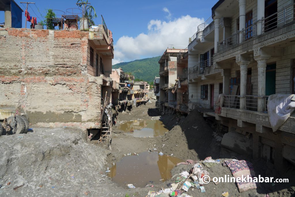

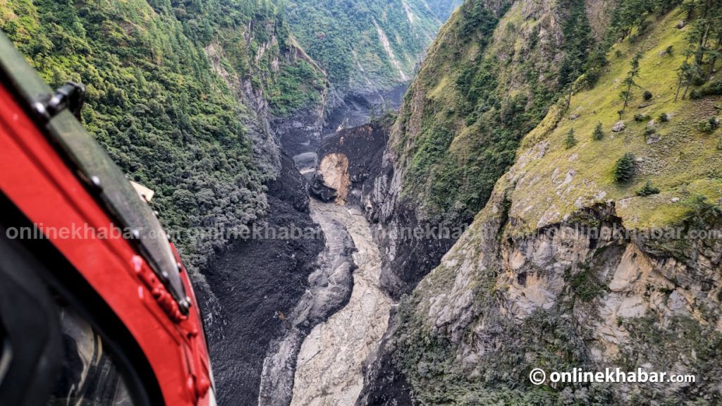
The Trishuli turned the colour of wet cement on August 26. A debris flood from the Tibet border had swept down the Bhote Koshi, turning the river thick and grey. Then it happened again. On September 27, a mudflow from the Ghatte Khola blocked the Marsyangdi near Chame, while a landslide briefly dammed the Kali Gandaki near Lete in Mustang. On the morning of October 11, the Budhi Gandaki rose in a flash flood, apparently after a landslide dam failed in Gorkha, and ran dark again.
Four rivers, six weeks, one unsettling sight.
The immediate damage from such events is familiar. Floods destroy bridges, roads and homes, disrupt livelihoods and take lives. But the colour of the water raises another question: what else are these rivers carrying away?
Along with rocks, debris and sediment, floodwaters may be stripping mountain catchments and river valleys of fertile soil accumulated over generations. If so, the damage extends beyond the destruction visible in photographs. It reaches into the foundations of mountain agriculture, livestock keeping and the ecosystems on which communities depend.
Nepal has good reason to worry about its retreating glaciers. Their loss is visible, measurable and increasingly well documented. Soil loss receives far less attention. Yet soil takes a long time to form, and once it is washed away, it can be extraordinarily difficult to replace.
Could the loss of soil from these floods ultimately prove harder to reverse than the loss of ice? That is not an established conclusion. It is a question that Nepal needs to investigate before more of this largely unmeasured resource disappears.
The story beneath the dark water

A river’s colour does not, by itself, reveal where a flood began. It tells us something about the material the water encountered along the way.
Debris floods and surges released by failed landslide dams carry enormous amounts of sediment. As they move downstream, they can erode riverbanks, uproot vegetation and sweep up material from terraces and riverside fields. The resulting mixture can turn rivers grey, brown or almost black.
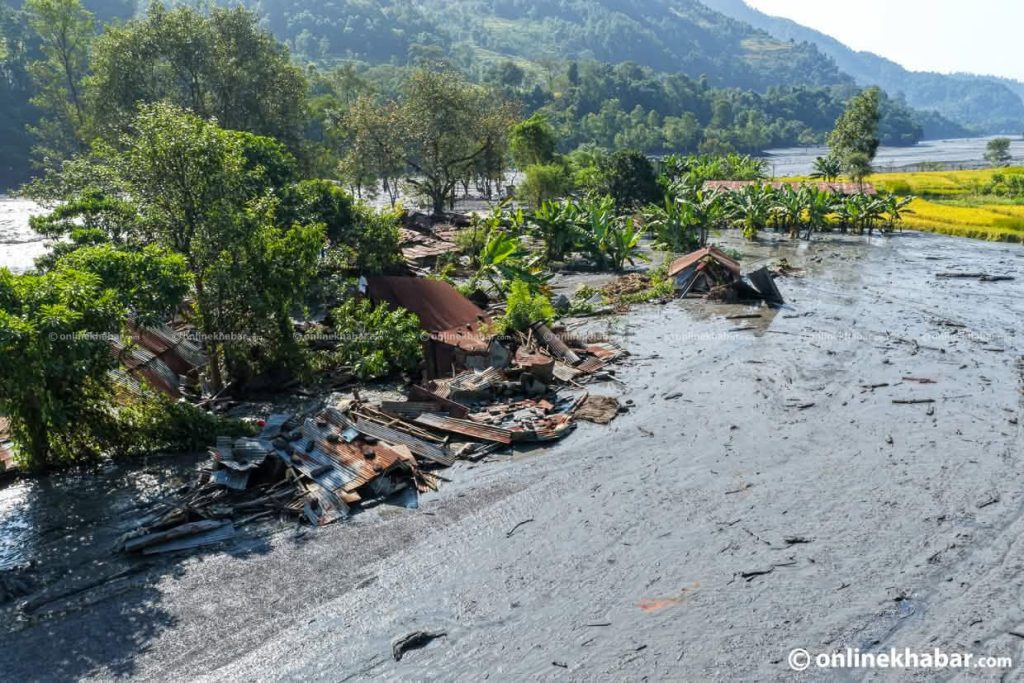
Field observations along the lower reaches of the affected rivers suggest that some of the dark material may have come from fertile river corridors, including paddy fields close to harvest. If confirmed, this would mean that floods had removed not only material from their source areas but also productive soils from places where people grow food.
The distinction matters. Sediment originating in a landslide or rockfall is not necessarily equivalent to topsoil lost from a cultivated field. The latter contains organic matter and nutrients accumulated through years of biological activity and farming. Its removal can undermine agricultural productivity long after floodwaters recede.
The colour alone cannot establish the origin of the sediment, however. Researchers need to collect and compare samples from flood deposits, landslide scars, riverbanks and agricultural fields. Without such evidence, the extent of farmland soil loss remains uncertain.
What is clear is that the floods have exposed a gap in how Nepal assesses environmental damage. We can count destroyed infrastructure, but we rarely measure the soil carried away with it.
A resource that takes generations to build

The significance of soil loss becomes clearer when we consider how slowly mountain soils develop.
At high elevations, cold temperatures shorten the growing season and slow the decomposition of organic matter. Over long periods, this material accumulates into thin, often dark layers above coarser ground. These soils support alpine vegetation, retain moisture and store carbon.
A survey of 405 soil profiles across the Tibetan Plateau’s alpine grasslands estimated that the top metre of soil contained about 7.4 petagrams of carbon, averaging 6.5 kilograms per square metre. Carbon density was higher in moist soils rich in clay and silt — fine materials that can be particularly vulnerable to erosion.
When these layers are stripped away, the ground beneath may retain less water and fewer nutrients. Vegetation can eventually return, but a green hillside is not necessarily a recovered hillside. Rebuilding the soil that sustained that vegetation may take far longer.
The same principle applies downstream, although floodplain soils develop under different conditions. Ordinary floods can replenish agricultural land with mineral-rich sediment. Violent debris floods, however, may strip fields bare or bury them beneath coarse material rather than deposit the fine sediment that supports cultivation.
A global analysis found that erosion from conventionally ploughed fields can occur one to two orders of magnitude faster than soil formation. The comparison illustrates how quickly productive land can lose ground, although the rate of damage from each Himalayan flood must be measured independently.
The central concern is not that every flood necessarily destroys soil. Flooding is a natural process, and sediment can sustain river ecosystems and replenish farmland. The concern is that increasingly destructive events may remove soil faster than natural processes can rebuild it.
When extreme rain reaches unexpected places
The question becomes especially important in the trans-Himalayan districts of Manang and Mustang, where farming and pastoral livelihoods depend on fragile mountain environments.
These districts lie in a deep rain shadow. Jomsom receives only about 255–295 millimetres of rainfall annually, and high-altitude slopes experience roughly 16 rainy days a year on average. A greater share of precipitation also arrives in winter than elsewhere in the basin.
Yet low average rainfall does not make these landscapes immune to intense precipitation. In May 2021, rainfall was 693 per cent above normal in Manang and 476 per cent above normal in Mustang. Chame recorded what was then its highest daily rainfall on record. This year, forecasters noted increased pre-monsoon rainfall despite a weak monsoon onset. A member of parliament also told the House that continuous rain disrupted life in Manang from around 24 to 27 September.
Long-term rainfall records, however, do not support a simple claim that the entire region is becoming wetter. Across the Gandaki basin, monsoon rainfall has shown a rising tendency, but the trend is not statistically significant. Winter and pre-monsoon precipitation have declined significantly, as has post-monsoon rainfall in the trans-Himalaya.
A 40-year analysis of 204 stations found that extreme-rainfall days become more frequent with elevation, with high-altitude stations experiencing more rare, intense storms. This is a geographical pattern, not evidence that such events have necessarily become more frequent over time. Annual rainfall totals in the trans-Himalaya show no statistically significant trend.
The picture is therefore more complicated than a straightforward increase in rainfall. Intense episodes can occur even where annual totals remain low or show no significant trend. For mountain communities, the timing, location and intensity of precipitation may matter as much as the total amount received.
This raises a hypothesis worth testing: intense rainfall may be flushing out topsoil that accumulated over long periods under conditions of snow cover or relatively light precipitation. If so, soils that developed over decades or centuries could be lost during a single event.
But this remains unproven. The age of the soil removed by the 2026 floods has not, to my knowledge, been measured. Dating the soil that remains in affected areas could help establish how long it took to form and how difficult it will be to replace.
Nor should the four floods automatically be treated as evidence of a single climate-driven process. Their triggers differed, ranging from an ice-rock avalanche near the Tibet border to rain-related landslide dams. Climate change is altering high-mountain environments and may intensify certain hazards, but each event requires separate investigation before its causes can be established.
The consequences extend beyond the riverbanks

Soil loss is not simply a question of agricultural output. In the Himalayas, it affects interconnected systems of vegetation, water, grazing and rural livelihoods.
Alpine pastures support sheep, goats, yaks and other livestock. Their productivity depends on the condition of the soil, the vegetation it sustains and the availability of water. When fertile ground is eroded or buried beneath debris, grazing capacity can decline, placing additional pressure on households that depend on livestock.
These grasslands also support yarsagumba (Ophiocordyceps sinensis), a valuable caterpillar fungus found largely in isolated patches of alpine grassland at elevations of 3,000–5,000 metres. Research in Dolpa has examined how soil characteristics and associated plants relate to its density and growth.
Whether climate change is shrinking the fungus’s range remains contested, with modelling studies reaching different conclusions. The effects of individual floods on its habitat are also not yet established. These uncertainties make local ecological assessment essential rather than optional.
Further downstream, the consequences are more immediate for farming communities. A field stripped of topsoil or buried beneath coarse debris may remain unproductive for several growing seasons. Restoring access to a road or rebuilding a bridge may be relatively straightforward compared with restoring the biological and physical properties of damaged soil.
The losses may therefore persist long after infrastructure has been repaired and the disaster has disappeared from public attention.
Measuring what the floods leave behind
Nepal’s post-disaster assessments need to account for these less visible losses. Recording damaged buildings, roads and bridges remains essential, but it provides an incomplete picture of what a flood has destroyed.
Researchers and local authorities should begin by comparing the material deposited by floods with soils from their source areas, riverbanks and nearby agricultural fields. Testing these samples for organic carbon and mineral composition would help establish whether the sediment includes substantial quantities of fertile topsoil.
Satellite imagery taken before and after an event could help map where material was eroded and where it accumulated. These observations should be combined with rainfall and river records, including measurements from high elevations, to establish the triggers and pathways of individual floods.
Equally important is documenting the consequences for pasture, farmland and water sources. Farmers, herders and other residents often know which fields were productive, where grazing conditions have changed and how local water sources have been affected. Their knowledge should inform assessments from the beginning, rather than being collected as an afterthought.
Where evidence supports intervention, restoration should be designed with the communities that depend on the affected landscapes. Rehabilitating a catchment, meadow or riverbank field requires an understanding of how the land is used, how it functions ecologically and what local livelihoods need from it.
These steps would not prevent every flood or eliminate soil erosion. They would, however, help Nepal establish what is being lost, distinguish temporary damage from long-term degradation and direct restoration towards the areas where it can make the greatest difference.
Glaciers we can see, soil we cannot

The four floods of 2026 had different triggers, and their causes must be assessed individually. We also cannot yet conclude that the soil they carried away represents a greater loss than Nepal’s retreating glaciers. The evidence needed to make that comparison does not exist.
That is precisely the problem. Glaciers are monitored from the ground and from orbit. Their changing extent and mass are increasingly well documented. The soil swept into the Budhi Gandaki on 11 October, by contrast, has no comparable record.
The absence of measurements should not be mistaken for evidence that the loss is insignificant. Soil supports agriculture, stores carbon, retains water and sustains the ecosystems on which mountain communities depend. Once removed, it may take generations to recover.
A river carries more than water. It carries the consequences of everything happening across its catchment, from high-altitude meadows to fertile paddy fields. Understanding those consequences requires looking beyond the flood itself to the landscapes that supply its sediment.
Nepal has rightly made glacier loss a major concern. It now needs to give soil erosion the same seriousness, beginning with systematic measurement rather than assumptions about how much has been lost or how long recovery might take.
The dark floods may ultimately prove to have caused less soil loss than initial observations suggest. Or they may reveal an environmental cost that Nepal has long overlooked. Only evidence can tell us which is true.
What we cannot afford is to keep counting the damage that is easy to see while ignoring the ground beneath our feet.