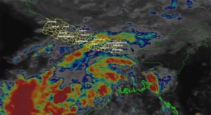


Kathmnadu, November 18
Three cyclones have developed in the Bay of Bengal in less than a month, raising questions about their possible impact on Nepal. After Arnab and Murasu, a new cyclone named Akvan has formed and is moving towards India’s Andhra Pradesh coast.
According to the India Meteorological Department (IMD), Akvan is expected to cross the coast around November 20. The system is forecast to intensify further and move in a north-northwesterly direction over the coming days.
The first of the three cyclones, Arnab, formed in the Bay of Bengal on October 25. Its associated low-pressure system brought rain and snowfall to Nepal from October 29 to 31.
Soon after Arnab weakened, another cyclone, Murasu, developed in the Bay of Bengal on November 1. It made landfall along the southern coast of Andhra Pradesh on November 3, but had little impact on Nepal.
Hailstorms and rain were recorded in Kathmandu Valley and surrounding areas on November 11, the day of Bhai Tika. Meteorologists, however, attributed the weather to westerly and local wind systems rather than the cyclone.
What impact could Akvan have on Nepal?
As Akvan has developed less than a month after Arnab, meteorologists in Nepal are closely monitoring its movement and possible effects.
David Dhakal, a meteorologist at the Meteorological Forecasting Division under the Department of Hydrology and Meteorology, said its impact would become clearer after the cyclone makes landfall, depending on its track and intensity.
Based on current forecasts, however, he said the system was unlikely to have a significant impact on Nepal.
“Initial estimates suggest that it could bring clouds towards the eastern parts of the country. Even if it causes rain, it is likely to be light and limited to one or two places. There is currently no indication that it will bring prolonged or heavy rainfall,” Dhakal said.
Dr Binod Pokharel, associate professor at the Central Department of Hydrology and Meteorology at Tribhuvan University, also said there was no clear indication of heavy rainfall in Nepal due to Akvan.
“Light rain is possible in a few places in the eastern half of Nepal on Sunday and Monday. There is no clear indication of heavy rainfall so far,” he wrote on Facebook.
Where is Akvan now?
According to the IMD, Akvan has been intensifying over the central parts of the south and adjoining west-central Bay of Bengal. It moved slowly northwards at around three kilometres per hour during the six hours preceding the department’s latest bulletin.
As of midnight on November 17, Indian time, the cyclone was located at 12.5 degrees north latitude and 85.6 degrees east longitude.
It was approximately 590 kilometres east of Chennai in Tamil Nadu, 640 kilometres northeast of Trincomalee in Sri Lanka, 630 kilometres southeast of Machilipatnam in Andhra Pradesh, 630 kilometres south-southeast of Visakhapatnam and 760 kilometres south of Gopalpur in Odisha.
The IMD forecast that the system would continue moving north-northwestwards and intensify into a severe cyclonic storm on November 18.
By the evening of November 19, it is expected to move northwestwards and strengthen further into a very severe cyclonic storm.
The cyclone is forecast to cross the coast between Nellore and Visakhapatnam in Andhra Pradesh and Yanam on November 20. At landfall, its maximum sustained wind speed is expected to reach 120–130 kilometres per hour, with gusts of up to 145 kilometres per hour.
Meteorologists say cyclones developing in the Bay of Bengal do not usually have a direct impact on Nepal. However, clouds along the outer edges of such systems can sometimes bring rainfall, snowfall and strong winds to parts of the country.