Imagine Kathmandu as a geographical mandala. The city, with its streets and frenetic life and crazy drivers, is the centre. The Ring Road is the circular boundary between this urban vortex and the green girdle of hills that tower above the valley floor. Beyond this rim is the even more tranquil, almost paradisiacal realm of mountains and villages, stone trails and moss-carpeted forests. This is how I, a habitual walker and lover of the outdoors, visualise Kathmandu compared to hiking destinations.
Needless to say, as someone who loves to hike and trek, the destinations at the top of my priority list are places as far away from the city as possible.
Sadly, like many city dwellers, there is more wishing in my life than hiking. Living in Kathmandu often turns into an inability to leave Kathmandu. There is work. Or opportunities: an offer is tabled that is too good to pass on. Friends come into the equation: there is always someone who can’t make it this weekend, this time, so the trip is postponed. And, above all, there is the procrastinator in us who tells us that the hike can be done another time. Before you know it you have forgotten about it altogether.
I have postponed more hikes and treks than I have been on. I still have a long list of treks in Nepal I want to do. It’s clichéd but it’s also true: if you want to go, just leave. It’s that simple. However, if you go on one short hike, the chances are you will go on another. After all, you don’t find hikers passionately discussing plans for that epic trip in coffee shops or next to water coolers. True hikers hit the trails, irrespective of the time of year, whether their friends can come or not.
Distance and duration – often the reasons for travelling, for leaving home – can also be deterrents. You want to go on a trek to, say, Langtang, but it’s too far. It will take too long. You don’t have the time. But Kathmanduites needn’t be bogged down by these factors. There are plenty of hikes around the Valley that, though they are no Langtang or Annapurna trek, offer enough of quiet, solitude, wilderness and wildlife to make you hit the trail instead of a Saturday morning movie. Here are some of the best hikes – short and long, easy and exacting – that Kathmanduites can do on weekends, on a shoestring.
1.
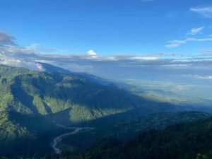
Sundarijal to Chisapani
The buffet for the senses begins within minutes of taking to the trail on this hike. You go up a narrow alley, a simple path around the corner of a building, from Sundarijal’s small bazaar and come out into the countryside. You climb past houses with pumpkins drying on window sills, pomelo and orange trees in the garden, and cows in sheds. Running parallel to the trail is a huge rusty pipe that carries water down from the reservoir high in the forest. In the ravine below is the Bagmati, flowing merrily, boisterous, clean.
You ascend, your calves object. Just then you hear a crashing sound of water, growing louder with each laborious couple of feet. Soon the source comes into view: a waterfall, plummeting from the dense forest. Water starts, their tails flitting like butterflies, hop from rock to rock.
The climb continues after the waterfall for another hour before you find yourself in terraced fields. This is Mulkharka. There isn’t another village between Mulkharka and Chisapani, so it’s best to buy snacks and refill your water bottles here.
Climbing up from Mulkharka, you enter another forest. The rest of the walk to Chisapani is through dappled forests. It can be a bit frustrating because the trees block views of the mountains. But when you finally get your first glimpse of the mountains towering above Chisapani, not seeing them all day enhances their beauty. There is hardly a better way to end a day than watching the day’s last light drain away, turning the peaks golden one moment, roseate another.
Duration: 7-8 hours, including stops for snacks and rests
Grade: Moderate. The uphill section is from Sundarijal to Mulkharka. Level trail after that.
Directions: Head up the stone trail from Sundarijal toward the reservoir. From Mulkharka, take the trail going northeast (left). Ask locals if you are confused.
Highlights: Waterfall, scenic villages, mountain views
Budget: 2,000 rupees
2.
Taudaha to Champa Devi
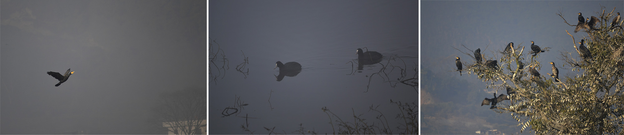
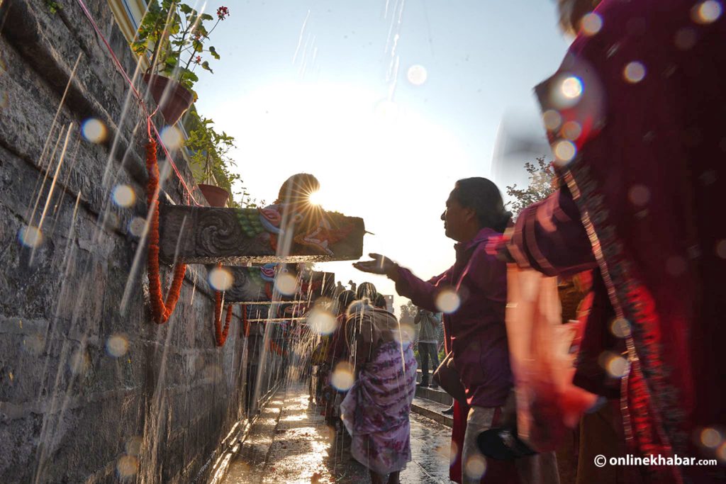
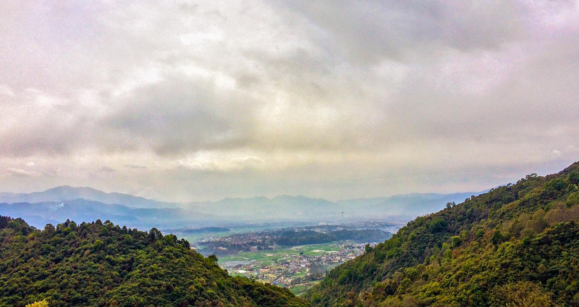
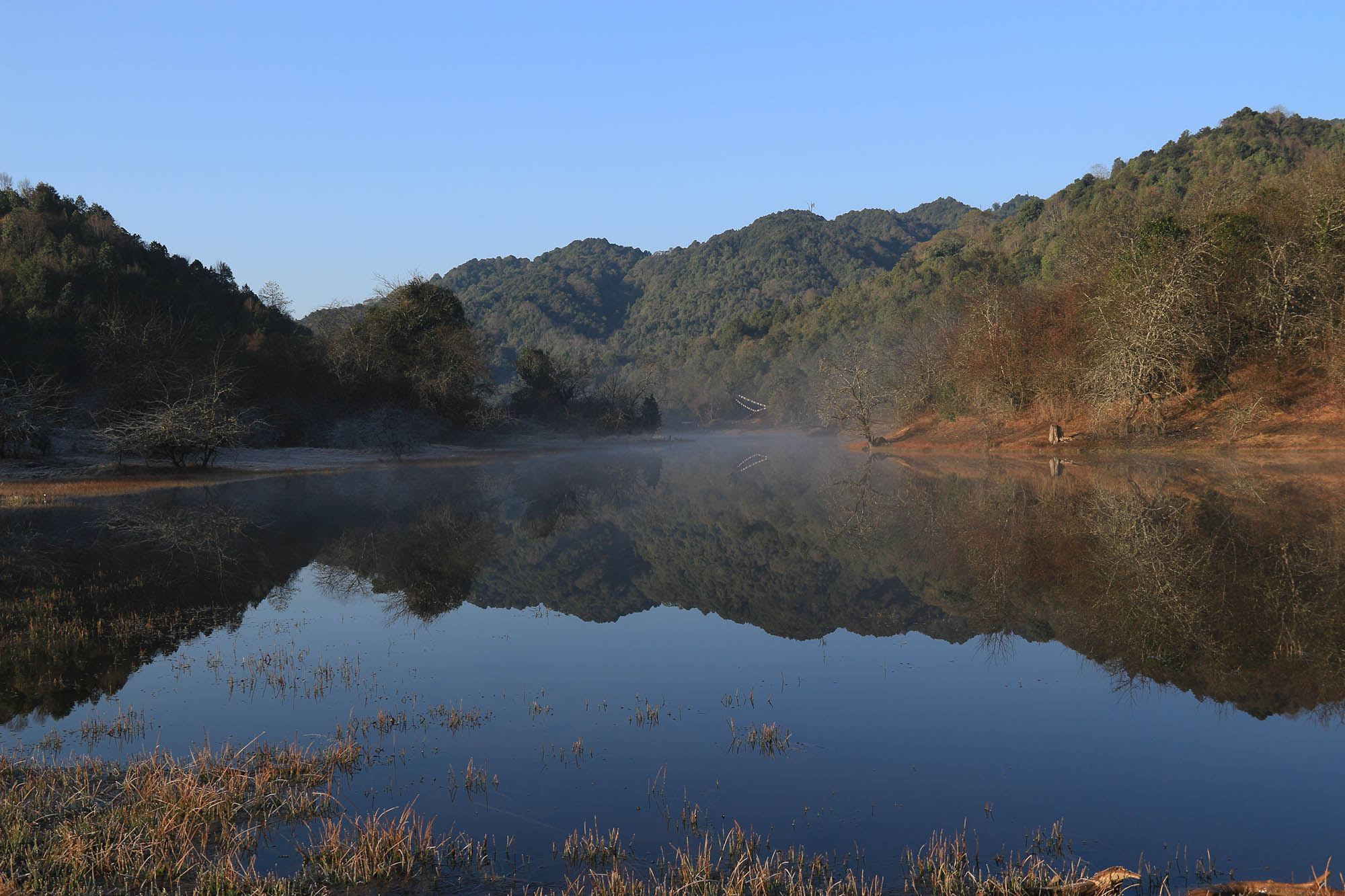
This hike is ideal for anyone who prefers solitude above all else. Not to say that is its only attraction. If you go in winter, you can begin by spending some time watching the numerous species of migratory birds wintering in Taudaha. The hike begins on the paved road that winds up from Chalnakhel. It’s a steep climb for the first half an hour. The road ends near a monastery damaged in the 2015 earthquake and now under construction, and a trail weaves through a small village of ochre houses. Walking past the houses, the trail climbs again, this time into the dense forest. This is the lonely stretch of the hike, your only company likely to be kalij pheasants foraging the leafy floor.
An hour of steady climbing will bring you to a saddle on the hill. The summit of Champa Devi Hill – and the shrine dedicated to the eponymous goddess – is a further thirty-minute climb west, reachable on flagstone stairs. A similarly paved trail goes to the east, winding down to Hattiban Resort and, further down, to the main Kathmandu-Pharping road.
On clear days, the view to the north is an unbroken chain of majestic peaks; the south is row after row of hills, floating above the haze. There is nothing spectacular about the Champa Devi shrine. It’s a small space with a couple of statues smeared with vermilion. But it’s awesome in its isolation, a place of power that does not invite devotees with its appearance or size but rather draws only those who seek out such places, those who are willing to punish their calves for an hour or two of solitude and a walk in the woods.
Duration: 3-4 hours
Grade: This is not a long hike; but it is exacting, mainly because it is uphill from start to finish.
Directions: Walk south on the Kathmandu-Pharping road after Taudaha. After four hundred metres, you will see a stream flowing across the road. A hundred metres down the road from this point, turn right on the road that goes uphill. This road goes to a monastery. A trail branches off from the road just below the monastery. Follow this all the way up to Champa Devi.
Highlights: Mountain views and a walk through dense forests
Budget: 500 rupees. There are no places after Taudaha to buy a meal or snacks, so carry your own food and water.
Alternative: You can catch a bus to get to or drive up to Himalayan Height Resort. You can also continue on the road to Dollu, from where you need to get to Samye Monastery. There are trails from both these places via the south face of the hill to the Champa Devi shrine. These routes will save you time and offer easier hikes than the north face route. Conversely, you can opt to descend via the south face.
3.
Pani Muhan to Kakani via Shivapuri National Park
For your calves, this hike is the stuff of nightmares. For the outdoors person in you, this is a long, sweet dream. The immersion in wilderness begins within moments of passing through the gate of Shivapuri National Park at Pani Muhan. Bird songs waft down from the canopy overheard. It takes a hundred metres and a bend on the trail to leave human habitation behind and be in the midst of a pristine forest.
There is a choice of going up to Shivapuri Peak via the Nagi Gompa or taking the stone stairs that branches off from the road a kilometre before the gompa. The latter, because it bypasses the monastery, goes through even denser forest. You labour up through a green tunnel. There are some trees on this stretch that are big enough to stop you on your track. It’s something of a wonder to find a living giant so close to Kathmandu, where every tree seems to be on death row. Persevering up this incline brings you to a small clearing in the forest. Tips of mountains are visible above the trees, titillating, promising stunning views from higher up.
The trail from Bagdwar, the source of the Bagmati River, to the summit is a relentless assault on your legs. In return, you get a 180-degree view of mountains and a smoky ocean with blue hills hovering over it. It’s a plunge downhill after the peak, through an area even denser than the south face of Shivapuri. It’s also lonelier. Occasionally, you will pass a villager headed for Kathmandu. At the foot of the hill the trail meets a gravelled road. There begins what seems an eternal walk to Gurjubhanjhyang. For a couple of minutes, you see vehicles. Your tickets are checked and you continue onward to Kakani, another long walk in the wilderness.
Duration: 10-11 hours
Grade: Challenging, suitable for only people used to for long walks. Involves steep climbs and long descents. The total distance covered on this route is nearly 35 kilometres.
Directions: Start at Pani Muhan, north of Budhanilakantha. A kilometre or so before the Nagi Gompa you will see a signboard that says ‘HELIPAD.’ Take that trail (stone steps). Follow the trail all the way to Shivapuri Peak. After descending from the peak (also stone steps) you need to turn right (north) at the first fork on the trail. This begins a long downhill section, which culminates in a motorable gravelled road. Turn left and head west. It’s a long walk, but you will eventually get to Gurjubhanjhyang, where there will be soldiers to tell you directions to Kakani, which is some eight kilometres away.
Highlights: Old-growth forests, bird watching, possible animal sightings, hours without sight of vehicles or human settlements
Budget: 2,000 rupees. Park entrance fee: 57 (Nepalis); 560 (foreigners)
No shops between Pani Muhan and Kakani. Carry lots of snacks and plenty of water.
Alternative: A watered-down version of this hike would be to walk up from Pani Muhan to Shivapuri Peak and back.
4.
Godavari to Phoolchoki

Phoolchoki, the highest of the hills surrounding the Kathmandu Valley, remains one of the most enticing hiking destinations around Kathmandu. It has a kind of pull about it: looming in the distance, a needle rising from its peak, it seems like an emblem of adventure, a call to stand on its summit.
Going up Phoolchoki, however, is no mountaineering feat; a gravelled road winds up from Godavari to its peak. A trail also goes up from the same place. The hike begins right at the foot of the mountain, so the walk for the first hour or so is on a steep trail. For religious folks, there is an opportunity to seek the blessings of Phoolchoki Mata at the small temple next to Navadhara, nine waterspouts. Culture buffs, too, will enjoy the conduits and temple.
Phoolchoki has some of the best-preserved forests of the hills around Kathmandu. Birdwatchers can look forward to spotting several species in a day’s hike. With luck, there will be glimpses of deer, wild boars, perhaps even a leopard. Even when the birds are out of sight, they make their presence felt with sweet songs or the spooky sounds of rustling leaves as they forage.
The ‘summit’ is a place of big rocks, a shrine, a stupa and an antenna. But eyes are likely to be looking further away, left to right, at a mountain panorama that includes Annapurna, Manaslu, Ganesh Himal, Langtang and Gauri Shankar. And looking down through rents in the smoggy veil hanging over the Valley, you can see Kathmandu and get a true scale of the place, the ancient lake it once was, and feel the pangs of loss of what must have been a place of unsurpassable beauty.
Duration: 4-5 hours
Grade: The first half of the hike is very demanding. It is a relentless climb.
Directions: Take the paved road opposite the Godavari Bus Park. It runs parallel to St. Xavier’s School’s western wall. After the ticket issuance office, head straight if you’re on a vehicle. Go left towards Navadhara, then climb the trail that skirts the temple’s compound. Follow the trail up until it merges with the road (by then a gravelled one). Signboards warning hikers to stick to the trail and not to take shortcuts abound. The reason for this is that there are many trails created by woodcutters that lead deep into the forest. So once you’ve found the road, stick to it.
Highlights: Excellent birding, wildlife, sweeping views of mountains and Kathmandu Valley
Budget: 500 rupees. Entrance fee: 10 (Nepalis); 100 (foreigners). Carry your own food and water.
5.
Godavari to Panauti via Phoolchoki
What was Kathmandu like before it became a bed of concrete houses? This is one thought that might cross your mind when you gaze down from Phoolchoki. Luckily, bits of the Kathmandu of a bygone era survive in Panauti. You can experience traditional Newar architecture in this medieval town by extending your Phoolchoki hike. Head down (east) on the flight of flagstone steps that forks off from the road a little below Phoolchoki peak. There is a worn out signboard nailed to a corrugated tin-roofed shelter that points the way.
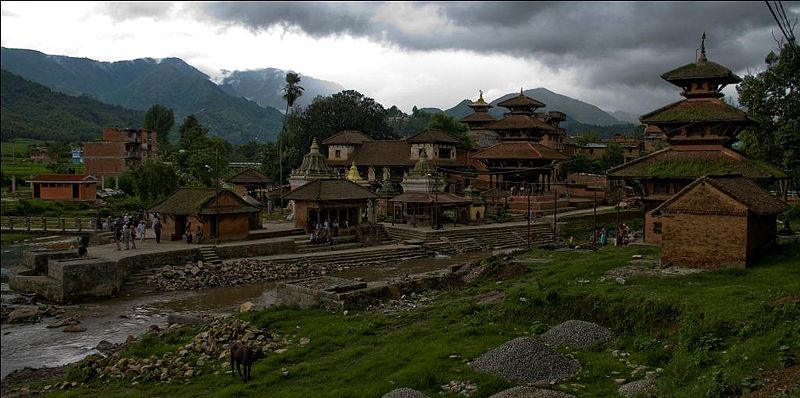
This is a long walk, weaving through forests, climbing up hills and passing by hamlets. The length of the hike is matched by the historical and cultural gems in Panauti such as the Indreshwor Mahadev Temple, a three-storied hulking testament to the artistry of the Newars and their ability to preserve traditions that go back centuries.
Duration: 4-5 hours
Grade: It is a descent all the way from Phoolchoki to Panauti. Although you will be walking downhill or on flat stretches for most of the way it is nonetheless quite a long walk. Not recommended if you go on hikes once in a bluemoon or if medieval era architecture sounds Greek to you.
Directions: Follow the stone stairs and you will be fine. The trail will pass through villages in a couple of places. Take this opportunity to confirm you are on the right path and to ask directions for the next stretch. Ask locals for the trail to Chalisé, from where it’s a paved road all the way to Panauti Bus Park.
Highlights: Trail alternates between dense forests and hillocks with lovely views of hills, terraced fields and quaint villages; mountain views; in winter, villages with trees laden with oranges; old Newar houses, ancient temples and a sacred ghat where three rivers merge.
Budget: 1,000 rupees
Alternative: Instead of returning directly from Panauti to Kathmandu there is the option to do an easy hike east to Namo Buddha. The walk takes between two and three hours, the last half hour of which is an uphill climb. Other than that it’s a stroll through an idyllic scene of farmers tending their immaculately raked fields. Add to that the chance to visit a sacred Buddhist pilgrimage site. Worth a visit even if you have no interest in religion or spirituality. The calm and silence and scenic beauty are reason enough to visit.
Directions: Cross the bridge across the road from Panauti Bus Park. Two hundred metres along this road (east) turn right to go to the Indreshwor Mahadev Temple; head straight if you wish to proceed to Namo Buddha.